

THIS ANNOUNCEMENT CONTAINS INSIDE INFORMATION FOR THE PURPOSES OF ARTICLE 7 OF THE MARKET ABUSE REGULATION (596/2014/EU) AS THE SAME HAS BEEN RETAINED IN UK LAW AS AMENDED BY THE MARKET ABUSE (AMENDMENT) (EU EXIT) REGULATIONS (SI 2019/310). UPON THE PUBLICATION OF THIS ANNOUNCEMENT, THIS INSIDE INFORMATION IS NOW CONSIDERED TO BE IN THE PUBLIC DOMAIN.
Trading Symbols
AIM: UFO FWB: I3A1
22 April 2026
Alien Metals Limited
(“Alien” or the “Company”)
For further information, please visit the Company’s website at www.alienmetals.uk or contact:
Alien Metals Limited
Bruce Garlick
Email: ir@alienmetals.uk
Strand Hanson (Financial and Nominated Adviser)
James Harris / James Dance / Edward Foulkes
Tel: +44 (0) 207 409 3494
Zeus Capital Limited (Joint Broker)
Harry Ansell / Katy Mitchell Tel +44 (0) 203 829 5000
Andy Thacker / Guy McDougall
Tel: +44 (0) 203 657 0050
Notes to Editors
Alien Metals Ltd is a mining exploration and development company listed on the AIM market of the London Stock Exchange (AIM: UFO). The Company follows a balanced strategy of advancing and strengthening its asset portfolio through targeted technical work and project development, while evaluating partnerships, joint ventures, and selective monetisation opportunities that are value-enhancing for shareholders. At the same time, Alien will continue to consider opportunities to expand our asset base through carefully selected acquisition opportunities which meet the Board’s prudent criteria.
Alien’s principal focus is the advancement and development of its 90%-owned Hancock Iron Ore Project in the central Pilbara region of Western Australia. The Hancock tenements contain a JORC-compliant resource of 8.4Mt at 60% Fe and offer significant exploration upside, which is targeted to deliver a mining operation of 2Mtpa for 10 years. The Project benefits from direct access to the Great Northern Highway, providing a route to export facilities at Port Hedland, one of the world’s largest iron ore export hubs. Alien also holds exploration interests in the Brockman and Vivash iron ore projects in the West Pilbara.
Alien additionally retains exposure to two advanced precious and base metal assets in the Pilbara. At Munni Munni, one of Australia’s largest PGM systems hosting a historic resource of 2.2Moz PGM (Palladium, Platinum, and Rhodium) and gold, the Company has completed its partial asset sale and joint venture transaction with GreenTech Metals Ltd, under which Alien has divested a 70% interest in the Munni Munni tenements to GreenTech and Alien will retain a 30% interest, free carried to the completion of a bankable feasibility study at Munni Munni. Alien (via wholly owned subsidiary A.C.N. 643 478 371 Pty Ltd) also retains a 30% interest in the Elizabeth Hill Silver Project through a joint venture with Crest, which encompasses the Elizabeth Hill Mining Lease M47/342, which has produced some of Australia’s highest-grade silver ore during the late 1990s. Alien retains a 30% interest in the Elizabeth Hill Silver Project and additionally holds 30.5 million shares in West Coast Silver Limited, providing both direct project exposure and equity participation in ongoing development.
Competent Person’s Statement
The information in this Report that relates to the current Mineral Resource estimate is based on, and fairly reflects, information compiled by Mr Phil Jankowski. Mr Jankowski is a full-time employee of ERM and is a Fellow of the Australasian Institute of Mining and Metallurgy. Mr Jankowski has sufficient experience relevant to the style of mineralisation and type of deposit under consideration and to the activity which he is undertaking to qualify as Competent Person as defined in the 2012 Edition of the Australasian Code for the Reporting of Exploration Results, Mineral Resources and Ore Reserves (JORC Code). Mr Jankowski consent to the disclosure of the information in this Report in the form and context in which it appears.
Appendix A – WCE ASX Release Titled “Elizabeth Hill Silver Project – 2.8 Moz Silver Mineral Resource Estimate” dated 22 April 2026
Elizabeth Hill Silver Project – 2.8 Moz Silver Mineral Resource Estimate
· West Coast Silver announces its inaugural Mineral Resource Estimate (MRE) for the Elizabeth Hill Silver Project, Western Australia.
· 2.79 Moz Silver from 141,000t at 617g/t Ag, including 369,000 oz Indicated and 2.42 Moz Inferred, reported above a 20 g/t Ag cut-off.
· Establishes Elizabeth Hill as one of Australia’s highest-grade silver deposits.
· Pit optimisation confirms Reasonable Prospects for Eventual Economic Extraction (RPEEE) within a compact open pit (~200 m x 180 m, 130 m deep) on a granted Mining Lease.
· Optimised pit captures almost all current mineralisation, including historical underground areas.
· The consensus metal prices used to define the open pit optimisation capture almost the entirety of the current mineralisation, including mining around the previous Elizabeth Hill underground operation.
· Mineralisation remains open along strike and at depth, with significant upside from near-mine and regional targets.
· MRE represents a foundation inventory, with clear potential for growth through ongoing drilling and geophysics across a ~180 km² land package
West Coast Silver Limited (ASX: WCE) (‘West Coast Silver’ or the ‘Company’) is pleased to announce the results of the inaugural Mineral Resource estimate (MRE) at the Elizabeth Hill Silver Project in Western Australia.
The MRE establishes a robust, high-grade foundation that will support continued development throughout 2026, paving the way for additional economic studies.
Commenting on the Mineral Resource Estimate (MRE), Executive Chairman Bruce Garlick said:
“West Coast Silver has progressed exploration at Elizabeth Hill rapidly to deliver a JORC 2012 compliant inaugural Inferred and Indicated Mineral Resource Estimate of 2.79 Moz Ag from 141,000 t at a grade of 617 g/t Ag above a cut-off grade of 20 g/t Ag. The inaugural MRE includes successful drilling results from 2025 exploration and an accurate depletion of ore mined between 1999 and 2000.
The MRE grade confirms Elizabeth Hill as one of the highest-grade silver projects in Australia. At a cut-off grade of 60 g/t, the resource contains over 2.72 Moz Ag from 76,000t @ over 1,114 g/t Ag. This is 97% of total MRE silver ounces and 54% of total MRE tonnes. The pit optimisation extends to the limits of most drilling and includes historical areas mined from underground. This speaks to the robustness of the deposit and the growth opportunities remaining at depth, along strike, and peripheral to existing mineralisation.
As 40% of MRE tonnes and 86% of silver ounces remain in the Inferred category, there is opportunity to significantly grow the MRE by further drilling within the open pit optimisation to convert Inferred resources to Indicated resource status.
This first Elizabeth Hill MRE is a benchmark for what is expected to be a continued high grade Ag growth story leading to the development of Australia’s highest-grade silver mine.”
2026 Mineral Resource Estimate
The 2026 Mineral Resource Estimate (MRE) has been completed in collaboration with mineral resource industry consulting firm ERM Australia Consultants Pty Ltd (ERM).
The Elizabeth Hill Silver Project is located 45 km south of Karratha, WA, on mining lease M47/342, held 70% by Crest Silver (West Coast Silver Ltd) and 30% by Alien Metals subsidiaries (Figure 1). The lease covers part of the Munni Munni Intrusive Complex, with silver mineralisation structurally controlled by the Munni Munni Fault and hosted in altered ultramafic and granite rocks within 50 m of the fault, with most mineralisation within 10 m. Silver is closely linked to silica-carbonate veining, forming high-grade, nuggetty native silver, mainly in ultramafic rocks.
In 2025, Errawarra Resources (now West Coast Silver) acquired 70% of the Elizabeth Hill Project after completing three drilling programs.
Mineralisation contains restricted, ultra-high-grade veins of native silver. An example of the ultra-high grades is the Karratha Queen silver specimen on display within the Perth Mint which contains 3,250 oz of Ag recovered from previous underground mining at Elizabeth Hill between 1999 and 2000. These veins are known to occur in structurally controlled shoots with dimensions not exceeding 5 m. For modelling, two domains were created. The first domain, using a cut-off of 20 g/t Ag, was chosen to define the outer limit of mineralisation. A second 5,000 g/t Ag high-grade domain was then modelled around mined historic high-grade underground stopes.
Inside the 20 g/t Ag domain, 1,150 g/t Ag and 13,000 g/t Ag were selected as cut-offs for high-grade indicators. Inside the 5,000 g/t Ag domain a 13,000 g/t Ag indicator was selected for the high-grade indicator.
For each domain, the proportion and grade were estimated by ordinary kriging; the final block grade is the weighted average of the proportion and grade estimated for each of the blocks.
A reconciliation was completed between previous production and the estimated model. The reconciliation showed that inside the mined stope the model has 102% of the tonnes at 126% of the grade compared with production. The recorded grade is the recovered grade and the amount of silver discharged to tailings is not well documented.
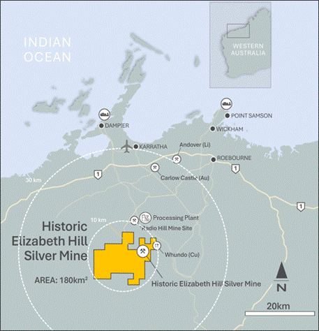
Figure 1: Elizabeth Hill Exploration Tenement Package and Mine Location
The Mineral Resource estimate is detailed in Table 1.
Table 1: Elizabeth Hill Mineral Resource estimate
JORC Classification
Tonnes (kt)
Ag (g/t)
Ag (koz)
Indicated
84
137
369
Inferred
57
1,331
2,426
Total
141
617
2,795
Notes to the Mineral Resource:
1. The tonnes and grades have been reported inside a pit shell.
2. The Mineral Resource is reported in accordance with the JORC Code 2012 Edition.
3. The Competent Person for the Mineral Resource is Phil Jankowski FAusIMM of ERM.
4. Mineral Resources are reported at a cut-off of 20 g/t Ag, constrained by an optimised open pit generated at A$85.71/oz Ag.
5. Rounding may lead to minor apparent discrepancies.
Open Pit Optimisation Parameters
A pit optimisation using Whittle software implementation of the Lerch-Grossman algorithm was completed to evaluate reasonable prospects for eventual economic extraction (RPEEE). Optimisation considered the potential of using standard open pit mining techniques, with a processing flowsheet of gravity-Merrill Crowe cyanidation-flotation. A metal price of $US60/oz Ag was used; other costs and physical inputs (Table 2) are based on ERM’s experience and are reasonable for the scale of the mineralisation. Based on the parameters adopted, the cut-off grade is 20.8 g/t Ag, which for reporting has been rounded to 20 g/t Ag.
Table 2: Open pit optimisation parameters
Parameter
Units
Value
Silver Price
$US/oz
60
USD/AUD Exchange Rate
Ratio
0.70
Silver Price
$AU/oz
85.71
Royalty
% of production
5%
Mining cost
$AU/t
4.50
Mining Dilution
% of insitu tonnes
5%
Mining Recovery
% of insitu tonnes
5%
Payability
% of production
99%
Processing cost
$A/t of plant feed
45.57
General and Administrative cost
$A/t of plant feed
3.00
Metallurgical recovery
% of head grade
90
Overall pit slope angle
Degrees
46
Table 3: Elizabeth Hill MRE by JORC classification grade tonnage table
Indicated
Inferred
Total
Cut-off
Tonnes
Ag (g/t)
Ag (oz)
Tonnes
Ag (g/t)
Ag (oz)
Tonnes
Ag (g/t)
Ag (oz)
0
118,907
100
382,159
80,563
940
2,435,318
199,469
439
2,817,482
20
84,117
137
369,248
56,696
1,331
2,426,218
140,812
617
2,795,472
40
49,694
211
336,988
41,823
1,795
2,413,261
91,516
935
2,750,255
60
35,551
275
314,030
40,522
1,851
2,411,311
76,072
1,114
2,725,347
80
30,795
306
303,291
38,353
1,952
2,406,597
69,147
1,219
2,709,894
100
23,782
369
282,439
37,200
2,010
2,403,500
60,982
1,370
2,685,947
The optimal open pit has a footprint of approximately 200 m by 180 m and a maximum depth of 130 m, reaching -15 m RL. It captures almost the entirety of the current mineralisation, including mineralisation around the previous underground operation. The mineralisation is insufficiently tested below the pit shell. Additional lodes, especially high-grade material down plunge and down dip, may produce a significant increase in the size of an optimal resource reporting pit.
Views of the optimized pit and resource block model coloured by classification are presented in Figure 2 to Figure 4.
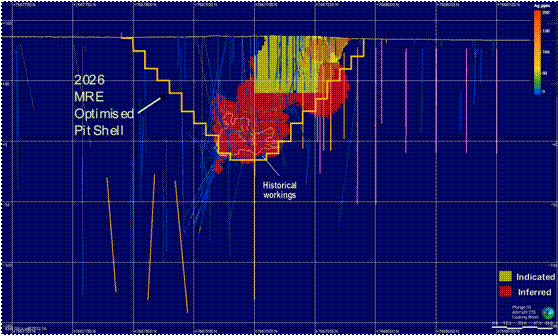
Figure 2: Long section view of block model with pit shell shown. Yellow=Indicated, Red=Inferred; Orange traces show planned and current diamond holes and pink traces show planned and current RC holes.
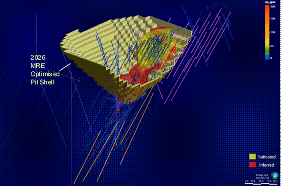
Figure 3: View from southeast of model > 20 g/t Ag with pit shell. Yellow=Indicated Red=Inferred; Orange traces show planned and current diamond holes and pink traces show planned and current RC holes; .pit wall sliced for clarity.
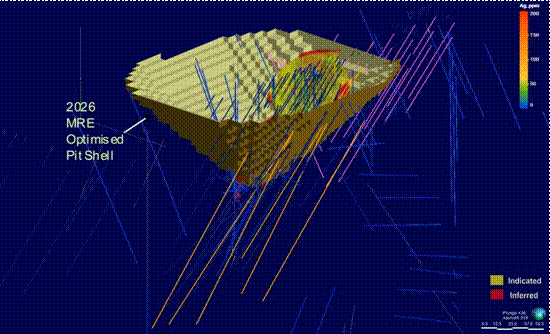
Figure 4: View from southeast of model > 20 g/t Ag with pit shell. Yellow=Indicated, Red=Inferred; Orange traces show planned and current diamond holes and pink traces show planned and current RC holes.
Listing Rule 5.8.1 Disclosure
Geology and Geological Interpretation
M47/342 covers part of the ultramafic basal portion of the Munni Munni Intrusive Complex (MMIC) of the Sisters Supersuite, that intrudes granitoids of the Cherratta Granitoid Complex.
A local geology map and schematic long section are presented in Figure 5 and Figure 6 respectively.
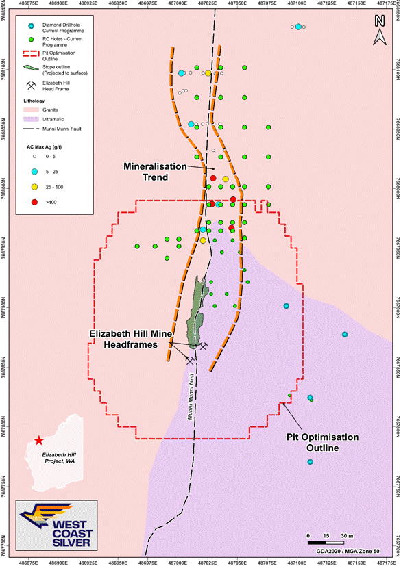
Figure 5: Plan View Elizabeth Hill MRE open pit optimisation outline over geology, 2025 aircore drilling results, 2026 planned diamond and RC exploration drill collars and historic underground mined area projected to surface.
Source: WCE ASX Announcement dated 24 February 2026 (modified)
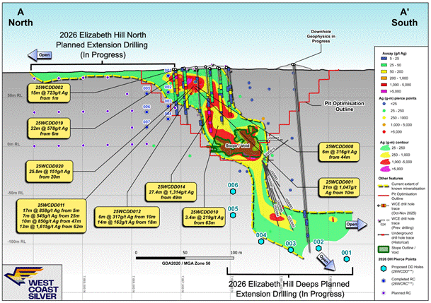
Figure 6: Schematic Longitudinal Section, Elizabeth Hill Mine showing 2026 MRE optimised pit shell, historical workings mineralisation grade distribution, planned 2026 RC and Diamond extension drilling (in progress).
Note. Longitudinal Section is a rendition of the interpreted Munni Munni Fault surface between granite rocks (west of sectional view) and the basal ultramafic lithologies of the MMIC (east of sectional view).
Source: WCE ASX Announcement dated 14 April 2026 (modified).
The MMIC is a complex layered ultramafic-mafic intrusion, with layers of dunite, lherzolite wehrlite olivine websterite, clinopyroxenite and websterite within the ultramafic zone. The general stratigraphy of the MMIC comprises an upper 3,630 m thick, generally massive Gabbroic Zone and a lower 1,850 m thick, layered Ultramafic Zone which dip moderately to the south. Within the project area, the MMIC comprises variations on pyroxenitic to peridotitic units of the lowermost Ultramafic Zone.
Foliated granite to granodiorite is a widespread component of the Cherratta Granitoid Complex, particularly around the MMIC. Additionally, various granitoids that have intruded the Whundo Group are included within the unit. The rock is locally k-feldspar porphyritic and weakly banded.
Primary igneous intrusive contacts between the MMIC Ultramafic Zone and the underlying footwall to the intrusive CGC are exposed northeast of the Elizabeth Hill mine and interpreted to plunge moderately south.
Silver mineralisation at Elizabeth Hill is structurally controlled and has a clear spatial and genetic association with the subvertical north-trending Munni Munni Fault. All the silver is hosted in fractured, veined, metasomatised and/or broken ultramafic and granite within 50 m either side of the fault, most within 10 m of the fault. The fault intersects the plunging granite-ultramafic intrusive contact at a high angle and offsets that contact several hundred metres, with an apparent east side down and lateral sinistral movement.
In cross section, the silver mineralisation is apparently controlled and localised around a flexure in the Munni Munni Fault with localised splays along structures and the granite-ultramafic contact away from the fault. Detailed modelling (ongoing) of the granite-ultramafic contact in the vicinity of the mine indicates a region of complicated geometry on that contact that most likely represents complex fault interactions with multiple fault planes anastomosing and intersecting.
The great majority of mineralisation is localised in structure that juxtaposes ultramafic against granite. Granite-granite juxtaposition on either side of the fault has only relatively minor silver mineralisation. However, this remains an area of active current exploration and previous conclusions may be influenced by exploration that has concentrated solely on that granite-ultramafic association, without examining possibilities beyond that relationship.
Within the mineralised zone, silver is intimately associated with silica-carbonate veining and alteration. High grade silver mineralisation often forms nuggetty networks of native silver adjacent to areas of intense carbonate veining in both ultramafic (dominantly) and granite (subordinately).
Several alteration types are recognised associated with the mineralised zones. These include:
· Breccias with both pyroxenite and granite/gneiss clasts
· Silica or calcite matrix
· Intense silicification in and around the Munni Munni Fault
· Completely silicified zones
· Quartz and calcite veins.
These zones within the fault area are often overprinted by later brittle fracturing deformation, most likely resulting from reactivation of the fault as a brittle fracture zone post-dating mineralisation.
Weathering is variably developed and ranges from subcrop of fresh rock at surface to penetration of oxidation and clayey alteration up to 30 m depth, typically associated with intense late brittle fracturing.
Drilling Techniques
A total of 1,602 drillholes for 17,405.9 m have been completed in the project area, as detail in Table 4. Most of the drilling meterage is from Diamond Drilling (DD) and Reverse Circulation (RC) drillholes.
Table 4: Summary of drilling history
Year(s)
No. of holes
Hole Type
Metres
1987
11
RC
805
1989
1
DD
12.9
8
RAB
187.5
2
RC
147
6
RCD
656.25
1999
8
DD
102.4
2000
10
DD
138.1
47
RC
2,419
693
SL
1,545.1
314
FC
526.95
2001
9
DD
392.6
2002
22
RC
2,367
2010
1
RC
180
2021
4
DD
213.2
1
TR
47
2022
3
RC
313
2025
6
AC
70
25
DD
2,186.05
Absent
78
DD
1,222.8
313
FC
525.55
40
RC
3,348.5
TOTAL
1,602
17,405.9
Sampling and Sub-sampling techniques
Historic Drilling
Alien Metals Drilling 2021-24
All RC samples are put through a cone splitter, and the sample was collected in a unique pre-numbered calico sample bag. The moisture content of each sample was recorded in the database.
The RC samples are sorted, oven dried, the entire sample is pulverised in a one stage process to 85% passing 75 µm. The bulk pulverised sample was then bagged and approximately 200 g extracted by spatula to a numbered paper bag that was used for the assay charge.
The DD samples were cut in half, and the right half of the core was submitted for assay. They are oven dried, jaw crushed to nominal <10 mm, 3.5 kg was obtained by riffle splitting and the remainder of the coarse reject was bagged while the 3.5 kg was pulverised in a one stage process to 85% passing 75 µm. The bulk pulverized sample was then bagged and approximately 200 g extracted by spatula to a numbered paper bag that was for the assay charge.
For some RC drilling, typically in areas where the geologist decides that there is no mineralisation, 4 m composite samples were taken and used for assay. The RC drill spoil samples were collected by traversing each sample pile systematically by scoop to obtain similar volumes of representative material for the nominated composite interval. This is regarded as a fit for purpose sampling regime for the type of drilling and the current stage of exploration.
Field duplicate RC sampling was also undertaken with the drillers collected a duplicate sample, at the same time as the main sample, off the second sample port on the cone splitter or re-splitting of the reject interval if using a riffle splitter.
The samples were then sent to Bureau Veritas Laboratory for sample preparation and analysis. At the laboratory, the samples were sorted and discrepancies to documentation notified to the Company, oven dried, crushed to -10 mm for core samples, riffle split if oversize and the bulk reject was retained. The sample was then pulverised in a vibrating disc pulveriser in a single step to 95% passing 105 µm, a ~200 g was split off and bagged for analysis and the bulk reject was retained. The sample sizes are appropriate for the geology and style of mineralisation being investigated.
Pre-2021 Historical Drilling
Various sampling methods have been employed previously for non-core drilling. Information is available for some anomalous drill holes discussed in this report. Samples for drill hole AG43 have been riffle split and spear sampled from drill spoils.
The CP cannot confirm but expects the core was cut and sampled according to industry standard (half core) techniques. Information on sample moisture content is available for some drilling. Where available most samples were dry.
Sample sizes have not been described in historical reports.
WCE Drilling 2024-present
Diamond Drilling
Samples for laboratory analyses were taken by sawing the DD core in half along a cutting line, which is offset from the core orientation line. The half of the drill core without the orientation line was collected for assaying. Duplicate samples were collected by sawing the remaining half core into two quarter cores, taking a quarter core but preserving the quarter core with the orientation line. Original and QAQC samples (standards, blanks and core duplicates) were sent to the laboratory for analysis (ALS Perth for all elements and secondary assaying at ALS Langley Canada for any over grade Ag assays).
DD core samples were fine crushed (CRU-42a) to 90% passing 3.15 mm. The sample was then rotary split directly from the crusher (SPL-22a) and pulverised to obtain 750 g to 85% passing 75 µm (method PUL-25e). These preparation methods are standard and appropriate for the samples.
The 1 m half core samples are appropriate to the grain size of the material being sampled. Where intervals of native silver were logged, these were sampled to mineralogical boundaries as low as 0.2 m in length.
Air Core Drilling
A hydraulic rotary sample splitter on the aircore rig was used to obtain a representative 2 kg – 3 kg sample of every metre drilled in a pre-numbered calico bag.
Based on geological logging, selected 1m samples were collected per hole for silver assaying, as part of a 48-element suite, with the remainder of the 1 m samples secured as back up to any composite samples collected in the same hole. If a hole was partially or not sampled on a 1 m basis, the rest of the hole was sampled as 2 m or 3 m composites.
All sampling excluded the transported cover rocks.
When compositing, a uniquely numbered calico bag was used, and the sample was collected by using a scoop through the sample pile to ensure the sample was as representative as possible.
One metre, and two and three metre composite samples were sent to the ALS Geochemistry laboratory in Perth for analysis of 48 elements, including Ag, by method ME-MS61L.
Samples were oven dried as required, fine crushed to 90% passing 3.15 mm, pulverised, and split to obtain a nominal 500 g sub sample for assaying. The remainder of the sample was to be retained as a coarse reject.
Certified Reference Material (CRM) standards (OREAS 608b & 611b), and blanks were inserted approximately every 25 and 50 samples, respectively. No field duplicates were collected as the drilling was deemed reconnaissance in nature.
The 2 kg – 3 kg sample size is considered appropriate for the material being sampled.
Sample Analysis Method
Historic Drilling
Alien Metals Drilling 2021-24
Assaying was completed by Bureau Veritas Laboratory in Perth, an accredited commercial laboratory. All sample results have been received.
For both RC and DD drilling samples, appropriate commercial CRM standards, blanks and field duplicates were submitted at the rate of around 5% of all samples.
An aliquot of sample was fused with Sodium Peroxide, and the melt was dissolved in dilute hydrochloric acid and the solution analysed via Inductively Coupled plasma (ICP) Mass Spectrometry (MS). The detection limit for Ag was 5 g/t Ag.
As part of normal procedures, Alien examined all standards and blanks to ensure that they are within tolerances. Additionally, sample size, grind size and field duplicate results are examined to ensure no bias to silver grade exists.
Pre-2021 Historical Drilling
Assaying and laboratory procedures are not available for most historical drilling. However, this information is available for some of the drill holes described in this report.
Samples were sent to Genalysis Laboratories for analysis of Ag only by a two-acid (perchloric/hydrochloric) digest with atomic absorption spectrometry (AAS) finish (lab code C/AAS) to a detection limit of 1 g/t Ag.
Some drill samples of each batch were check assayed at Genalysis and Ultra Trace Laboratories by an accelerated cyanide leach with an AAS finish (lab code Leachwell/AAS) to a detection limit of 1 g/t Ag.
Some samples of each batch were also analysed by Genalysis for Ag only by an Aqua Regia digest with an AAS finish (lab code B/AAS) to a detection limit of 0.1 g/t Ag. The tenor of results from different analytical techniques and different laboratories was generally comparable. The Competent Person (CP) could not independently verify the QA/QC of these analyses.
C/AAS is considered a partial extraction.
West Coast Silver has completed sufficient verification of the assay data, and in the CP’s opinion it provides sufficient confidence the assaying was appropriate for the mineralisation present and is fit for purpose.
None of the previous reports that have been reviewed by West Coast Silver to date specified the use of any spectrometers or handheld XRF tools.
Information on sample preparation and QA procedures is not available for most drilling.
WCE Drilling 2024-present
Diamond Drilling
Laboratory samples were analysed at ALS laboratories (Perth) for 48 elements, four acid digestion and ICP-MS finish. Samples with above upper detection limit analyses (>100 g/t Ag) were then analysed at ALS Perth with Ag-OG62 (four acid, ore grade Ag), ME-OG62 (four acid ore grade elements), Pb-OG62 (ore grade Pb – four acid) and Zn-OG62 (ore grade Zn – four acid). For Ag assays >1,500g/t Ag, samples were sent to ALS Langley (Canada) for analysis by Ag-GRA21 (Ag 30g FA-GRAV finish). For Ag assays >10,000 g/t, samples were then further analysed at ALS Langley by Ag-CON01 (Ag concentrate).
Four acid digestion is considered near total digestion.
The first samples analysed at the start of each hole were a blank then a standard before assaying of core samples, then ending the sample run for the hole with a standard then a blank.
CRM standards (OREAS 303b, OREAS-602c, OREAS-608b, OREAS-611b) were inserted in the sampling stream as every 25th sample. Duplicate samples (quarter core) were collected as every 50th sample. Irrespective of where intervals of native silver were sampled in the hole, a duplicate sample was collected which was followed by insertion of a blank.
Acceptable levels of accuracy and precision have been established for all CRM standards and for the majority of the blank material.
Four blanks which had been inserted after core intervals with visible native silver showed some contamination of the blanks from the previous extremely high-grade Ag sample of <1% relative as carry-over from the crusher and pulveriser. The CP considers the levels of carry-over is acceptable and there was no direct evidence of further contamination after the blank on succeeding samples.
Air Core Drilling
Laboratory samples were analysed at ALS laboratories (Perth) for 48 elements, four acid digestion and ICP-MS finish. Samples with above upper detection limit analyses (>100 g/t Ag) were then analysed at ALS Perth with Ag-OG62 (four acid, ore grade Ag), ME-OG62 (four acid ore grade elements). For Ag assays >1,500 g/t Ag, samples were sent to ALS Langley (Canada) for analysis by Ag-GRA21 (Ag 30 g FA-GRAV finish).
A 0.25 g split of the samples were analysed with the ALS ME-MS61L method that provides ALS’s lowest detection levels (0.002 g/t for Ag) from a four-acid digestion with 48 elements determined by ICP-MS.
ME-MS61L is considered a near total digestion.
Standards and blanks were inserted in the sampling sequence for analysis with the ME method.
Acceptable levels of accuracy and precision have been established for all CRM standards and for all but one of the blank materials.
Aircore assays are regional geochemical results that are used to identify areas for further follow up exploration, and anomalies identified generally consist of several elevated samples. The CP notes minor carry-over contamination in one blank sample from the pulveriser or crusher does not affect anomaly identification.
Mineral Resource Estimate and Classification
Silver mineralisation domains were modelled using Leapfrog Geo. Given the very high variability of mineralisation, and the known occurrence of extreme grades, it was recognised that multiple domains would be required.
For the domaining exercise, all available data was used. To supplement the drilling and sampling data, a grid of flat lying pseudo-drillholes on a 5 m by 5 m grid was created and intersected with the historic stope. These intersections were used to supplement the intersections of drillholes, and in places expand the outer contact to ensure the mineralised domain captures all the stope.
In each domain, the domained composite datasets are highly skewed, with high coefficient of variance and maxima in the percentage range. This is a result of the presence of small, extreme grade structures that could not be either effectively sampled by the drilling grid or sub-domained.
An indicator approach for grade interpolation was used to restrict the influence of the high-grade Ag composites. For the 20 g/t Ag domain the following approach was adopted:
• Estimate the proportion (IND2) of each block between ≥ 1150 g/t Ag and < 13,000 g/t Ag by indicator kriging, the proportion will be between 0 and 1.
• Estimate the proportion (IND3) of each block ≥ 13,000 g/t Ag by indicator kriging, the proportion will be between 0 and 1.
• The proportion (IND1) of each block < 1150 g/t Ag will be IND1 = 1 – IND2 -IND3.
Grades for domain 20 g/t Ag domain were interpolated in three bins:
• Bin 1 (AG1) only used composite grades < 1150 g/t Ag.
• Bin 2 (AG2) only used composite grades between ≥ 1150 g/t Ag and < 13,000 g/t Ag.
• Bin 3 (AG3) only used composite grades ≥ 13,000 g/t Ag.
The final grade (AG_PPM), a weighted average for each block is then calculated by the following formula:
• AG_PPM = (IND1 * AG1) + (IND2 * AG2) + (IND3 * AG3)
A similar approach was used for the 5,000 g/t Ag domain:
• Estimate the proportion (IND5) of each block ≥ 13,000 g/t Ag by indicator kriging, the proportion will be between 0 and 1.
• The proportion (IND4) of each block < 13,000 g/t Ag will be IND4 = 1 – IND5.
Grades for domain the 5,000 g/t Ag domain were interpolated in two bins:
• Bin 4 (AG4) only used composite grades < 13,000 g/t Ag.
• Bin 5 (AG5) only used composite grades ≥ 13,000 g/t Ag.
The final grade (AG_PPM), a weighted average for each block is then calculated by the following formula:
• AG_PPM = (IND4 * AG4) + (IND5 * AG5)
Validation of grade estimates was completed by:
• Manual check of order relations with no issues identified
• Visual checks on screen in cross section and plan view to ensure that block model grades honour the grade of the composites
• Statistical comparison of composite and block grades
• Generation of swath plots to compare input and output grades in a semi-local sense, by easting, northing and elevation
• Reconciliation of the previously mined stope with the current block model.
Drilling produced a coherent, geologically plausible interpretation of the mineralisation that matches the known controls.
The QAQC data available for the recent data demonstrates it is of acceptable quality, being reasonably accurate and precise and fit for purpose of estimating the Mineral Resource.
The comparison between the model prediction and the production records is reasonable, with the caveat that the production records are suspected of being incomplete and do not account for the Ag discharged to tailings.
Previous mining has demonstrated that the mineralisation was able to be mined from a selective underground operation; less selective open pit mining is therefore highly likely to be able to define and extract mineralisation at the calculated economic cut-off of 20 g/t Ag.
In the resource dataset, there is a relatively dense grid of recent surface RC and diamond drillholes in the upper, northern lobe; in the deeper southern lobe the majority of the available data comprises underground diamond drilling, face and channel samples, and sludge holes. To reproduce the shape of the mineralisation as demonstrated by the previous stopes, it was necessary to use the grades from this data; however the quality of the sampling from face samples and sludge drilling is not generally suitable for resource estimation.
A distance buffer of 7.5 m from the existing drill data in the upper part of the mineralisation was used to classify Indicated; other blocks were classified Inferred.
Grade Cut-off Parameters
Based on the parameters outlined in the Mining Factors and Assumptions used in pit optimisation, the calculated cut-off grade is 20.8 g/t Ag, which for reporting purposes has been rounded to 20 g/t Ag.
Mining and Metallurgical Methods and Parameters
A pit optimisation was completed to demonstrate reasonable prospects for eventual economic extraction (RPEEE). Optimisation considered the potential of using Gravity – Merrill Crow – Flotation processing with assumed costs of:
• Silver price of A$85.71 (US$60 at AUD/USD exchange rate of 0.70)
• Royalty of 5%
• Payability of 99%
• Mining cost of A$4.5/t of rock
• Mining dilution of 5%
• Mining recovery of 95%
• Processing cost of A$45.57/t of feed
• General and Administrative cost – A$3/t of feed
• Processing recovery – 90%
• Overall pit slope angle – 46 degrees.
Based on the parameters outlined above, the calculated cut-off grade is 20.8 g/t Ag, which for reporting purposes has been rounded to 20 g/t Ag.
Previous production at Elizabeth Hill utilised a gravity circuit. Historical recovery data is not available. A processing flowsheet of gravity-Merrill Crowe cyanidation-flotation was considered for the pit optimisation with an assumed recovery of 90%.