

On April 14, Typhoon Sinlaku struck the Northern Mariana Islands as a powerful Category 4 storm, with sustained winds of 150 mph, gusts up to 185 mph, and heavy rainfall. Saipan and Tinian bore the brunt of the impact – widespread power outages, heavy flooding, and significant damage to homes and infrastructure. Guam, though spared a direct hit from the eye, still experienced flash flooding and power disruptions.
The storm also destroyed the tools used to track it. Sinlaku knocked out the region’s ground-based weather radar systems and the majority of rain gauges, leaving emergency managers with no way to observe exactly how much rain was falling across the islands.
NASA Data Fills the Gap
The Northern Mariana Islands and Guam are U.S. territories, and Sinlaku’s landfall triggered a coordinated federal response that included FEMA, the U.S. Geological Survey, the National Weather Service (NWS), and NASA. During an interagency coordination call, the NWS reported that ground-based radars had gone offline due to the storm, leaving responders without rainfall observations for the region. Rainfall data is essential to emergency response during hurricanes. It helps responders understand where flooding is occurring, how severe conditions are, and where resources are most needed. Recognizing the gap, NASA’s Disasters Program mobilized rapidly, sharing IMERG satellite precipitation data for the full duration of the storm. These were the only rainfall measurements available to the U.S. response.
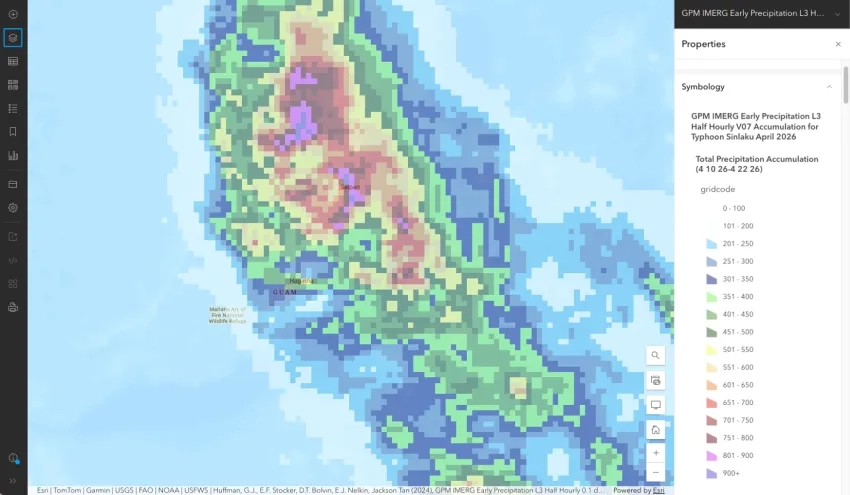
Example of data shared with response partners on the NASA Disasters PORTAL showing IMERG satellite rainfall estimates across the Northern Mariana Islands and Guam for April 10-22, 2026. Credit: NASA
IMERG – Integrated Multi-sateliltE Retrievals for GPM – combines data from an international constellation of satellites led by NASA and JAXA’s Global Precipitation Measurement (GPM) mission. The satellites continuously monitor precipitation across the entire globe, including remote islands, open ocean, and areas where ground infrastructure is limited. Estimates are updated every 30 minutes and are available within 1–2 hours of collection, making the data useful during disasters where conditions on the ground are constantly changing.
The GPM satellite’s instruments also scanned Sinlaku in three dimensions when it flew over the storm’s eye, providing detailed observations of frozen and liquid precipitation from the ocean to the upper atmosphere. These data gave scientists a detailed look at the storm’s internal structure and intensification processes.
The NASA/JAXA GPM Core Observatory flew over Typhoon Sinlaku at 10:08 pm LST (12:08 UTC) April 12 as it was rapidly intensifying, collected detailed 3D measurements of precipitation within the storm. Credit: NASA
Beyond Rainfall
Precipitation data is just one piece of a broader NASA response. The NASA Disasters Program has also provided Black Marble nighttime light imagery to track power outages and restoration, landslide hazard maps, and commercial satellite imagery through NASA’s Commercial Satellite Data Acquisition Program. The typhoon has passed, but response is ongoing, and NASA continues to provide data and mapping support as island residents work through the aftermath.