

This document proposes that a sophisticated pre-Holocene maritime civilization inhabited the now-submerged continental shelves during the Last Glacial Maximum (when sea levels were ~400 feet lower). The civilization drowned catastrophically between 14,600 and 8,200 BC as seas rose, and the survivors retreated inland to become the founders of early historical civilizations like Egypt, Sumer, and the Indus Valley.
Three core arguments support this thesis:
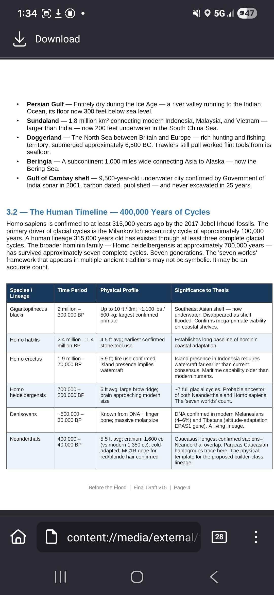
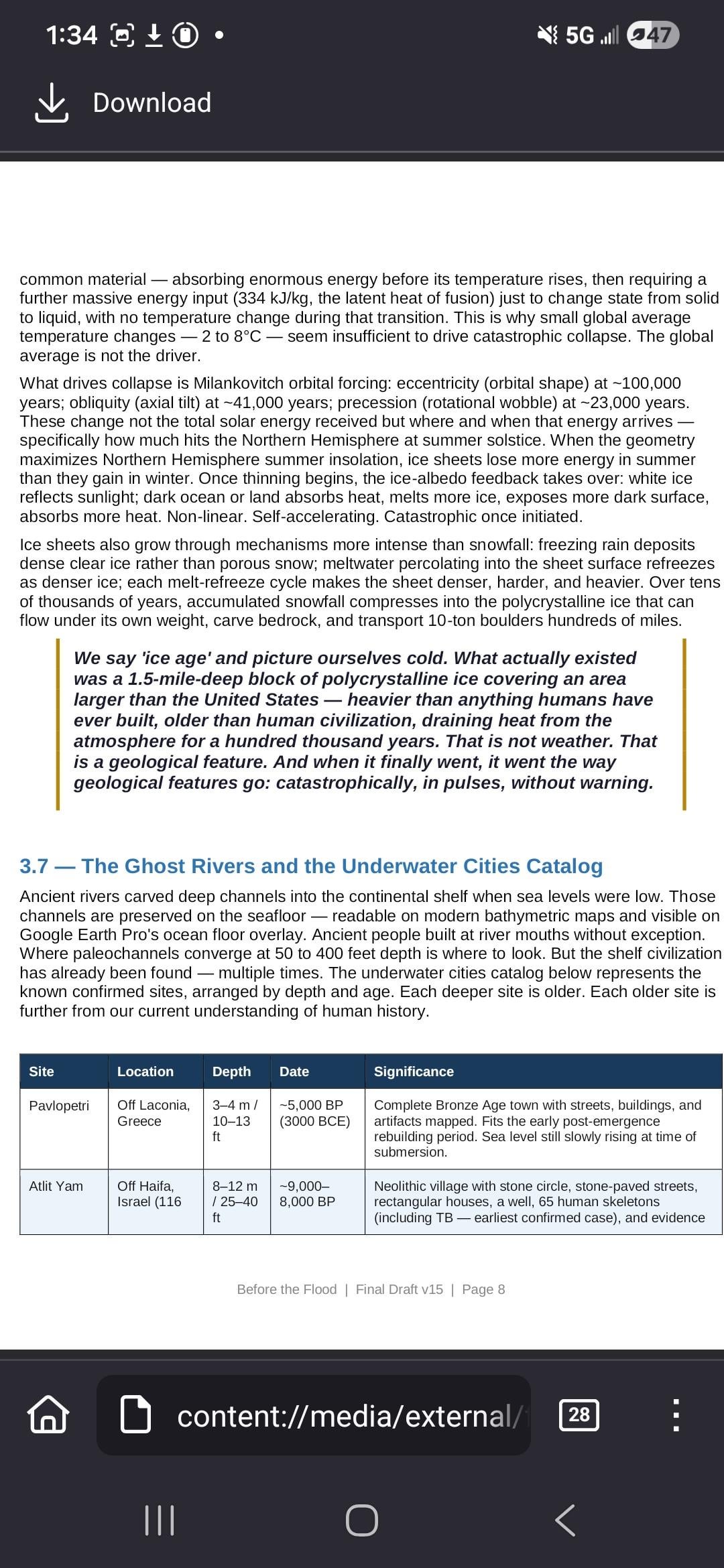
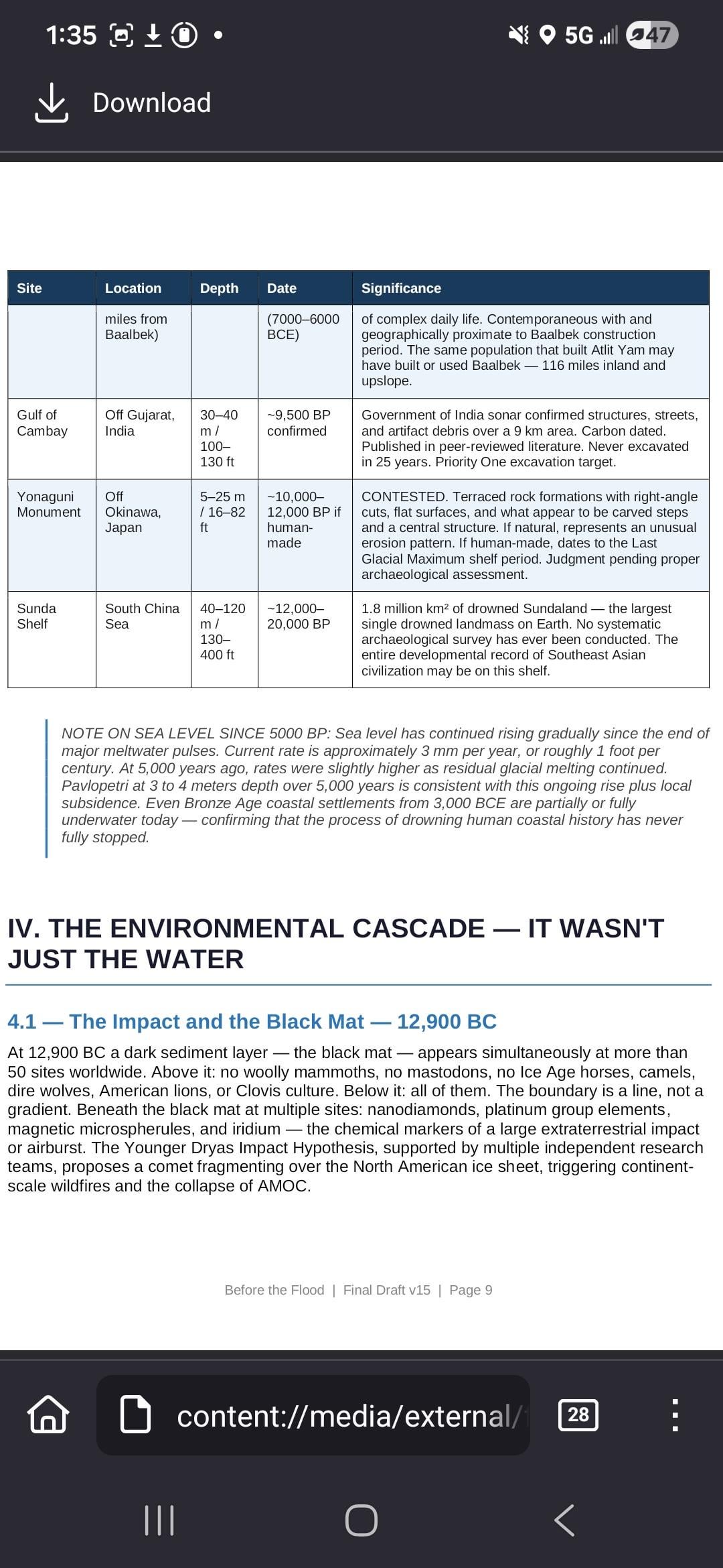
The Shelf Hypothesis argues that the continental shelves—now underwater but previously exposed land covering 15 million square kilometers—were the most productive and climatically favorable zones on Earth. These areas supported sophisticated populations for hundreds of thousands of years. Evidence includes the confirmed underwater city in the Gulf of Cambay (discovered by the Indian government, dated to 9,500 BP, but never excavated) and other submerged sites like Doggerland, Sundaland, and Beringia.
The Environmental Cascade explains why survivors couldn't simply rebuild quickly. The sea level rise wasn't isolated; it occurred alongside simultaneous collapse of temperature stability, food systems, trade networks, and biological nutrition. Recovery took millennia because everything failed at once, and inland environments offered far fewer resources than coastal zones had provided.
The Degradation Pattern shows that across multiple continents and independent cultures, the archaeological record reveals technical capability declining over time rather than improving—the opposite of what we'd expect from cultures developing from scratch. Stone precision, navigational range, fishing capability, and architectural ambition all show this same downward trajectory, with no developmental precursor visible. This signature suggests knowledge arrived already advanced and then degraded over centuries of catastrophic disruption.
Additional key points:
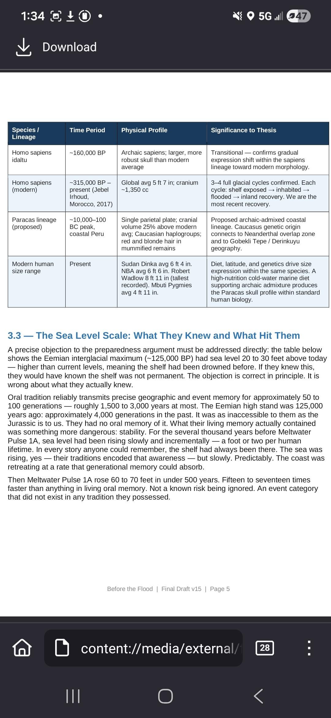
The civilization was fully human—anatomically modern humans built megalithic sites, sailed oceans, encoded astronomical data, and developed advanced techniques. Their descendants didn't vanish; they forgot. The author compares this to how Roman concrete formulas and Greek fire were lost after Rome's fall, but scaled globally across a 6,000-year cascade of flooding, cold, famine, disease, and forced migration.
The document argues that major religious traditions worldwide—Genesis, the Vedas, the Avestan texts, Hopi traditions, Andean oral records—preserved memory of these actual events, not mythology. When oral traditions have been tested against the scientific record, they've proven remarkably accurate with geographic specificity, warranting serious consideration of unconfirmed traditions as hypotheses.
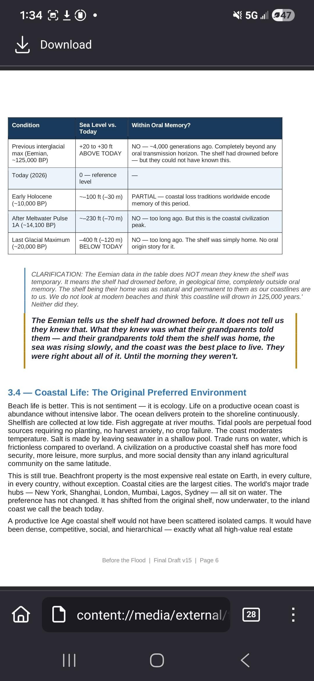
Regarding preparedness: while an earlier interglacial (the Eemian, 125,000 years ago) had sea levels higher than today, this was beyond the ~50-100 generation oral memory horizon (~1,500-3,000 years). Before the catastrophic Meltwater Pulse 1A, sea level had risen slowly and predictably. When the pulse hit—raising 60-70 feet in under 500 years, 15-17 times faster than anything in living memory—it was an unprecedented event category their traditions could not have anticipated.
by C_B_Doyle
3 Comments
There is between 28 million km^2 – 32 million km^2 of land lost in the last 20,000 years underneath 400 ft of water.
That is about 75% of the surface area of the Moon on the high end.
edit: This is a scientific fact and easily verifiable. Downvoting this does not make it false you cretins.
[Full Version: Before The Flood (PDF) ](https://files.fm/u/jpewcrprzx)
Thats a lot of text and assumption but a little light on actual evidence to back up your claims.