
26–20 ka BP — Ice Sheet at Its Peak
Laurentide Ice Sheet dominates Hudson Bay.
Ice streams carve deep troughs and proto–Great Lakes.
Sea level ~120 m lower, exposing shelves for later floods.
Evidence: Laurentian Channel, ice-stream bedforms.
20–17 ka BP — Ice Retreat & Lake Building
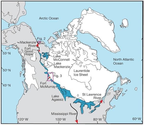
Southern ice margin melts, forming massive lakes (Agassiz, Iroquois).
Water gets trapped → unstable lake levels.
Subglacial floods carve channels, deposit sediments.
Evidence: tunnel channels, varved sediments, old shorelines.
17–15 ka BP — Ice Dams & Spillovers
St. Lawrence blocked repeatedly → lakes rise until dams break.
Overflow cuts new channels (Chicago, Michigan, east).
Evidence: thick sediment layers, delta terraces.
14.65 ka BP — Meltwater Pulse 1A
Global sea level jumps fast, dumping huge freshwater into oceans.
Can slow or collapse North Atlantic circulation.
Evidence: coral terraces, oxygen isotopes.
14.6–13.3 ka BP — Big Ice-Dam Failures
Lake Agassiz extremely high → catastrophic floods.
Floods carve cross-shelf troughs, send sediments offshore.
Evidence: Agassiz layers, turbidites, shelf channels.
Same Time — Backed-Up Floods Inland
Rising Atlantic slows coastal outlets → water reroutes to Mississippi, Ohio, Appalachian rivers.
Big basins flood, leaving slackwater deposits.
Evidence: paleochannels, fine sediments, inland turbidites.
13.3–12.9 ka BP — Flood Maximum
Lake Agassiz hits largest size.
St. Lawrence openings release massive pulses → offshore turbidites.
Evidence: graded sediments, isotope shifts.
12.9 ka BP — Younger Dryas Begins
Freshwater pulses + meltwater trigger AMOC collapse.
Sudden cooling 5–15 °C, wetlands and megafauna affected.
Evidence: black mat layers, isotopes, ecological changes.
12.9–11.7 ka BP — Outlets Reorganize
Ice retreats, northern outlets stabilize.
Great Lakes drainage shifts north; interior flooding decreases.
Evidence: uplifted shorelines, abandoned channels, varve counts.
12.9–11.7 ka BP — Red Sea Lowstand & Reflooding
Red Sea isolates → hypersaline.
Melt pulses reconnect it → rapid regional floods.
Evidence: bathymetry, salinity proxies.
11.7 ka BP — End of Younger Dryas
AMOC restarts → warming.
Champlain Sea forms over parts of St. Lawrence.
Evidence: marine shells, rebound-corrected shorelines.
11.5–10 ka BP — Ice Collapse & Outlet Migration
Laurentide collapse accelerates.
Northern outlets rise; old channels get buried.
Evidence: seismic profiles, paleovalleys.
10–8 ka BP — Shelf Drowning
Continental shelves fully flood → modern coasts locked in.
Evidence: drowned shorelines, filled estuaries.
8–7.6 ka BP — Early Holocene Wet Periods
Mega-lakes expand (Caspian, Xinjiang), Sahara green.
Later transitions to modern dry belt.
Evidence: beach ridges, lake cores, pollen records.
7.6–5.6 ka BP — Black Sea Flood
Rising sea overtops Bosporus → rapid flooding of Black Sea basin.
Evidence: submerged settlements, salinity jumps, delta changes.
6–4 ka BP — Late Holocene Stabilization
Carolina Bays, Great Lakes, and other basins settle into modern drainage.
Evidence: terraces, dunes, stable shorelines.
2 ka BP – Today — Preserved Records
Shelf troughs, turbidites, slackwater deposits, black mats, freshwater isotopes remain as evidence of all these events.
by C_B_Doyle
1 Comment
I really enjoy anything on the Younger Dryas Impact!