

Timeline:
26–20 ka BP — LGM Peak: Boundary Conditions Locked In
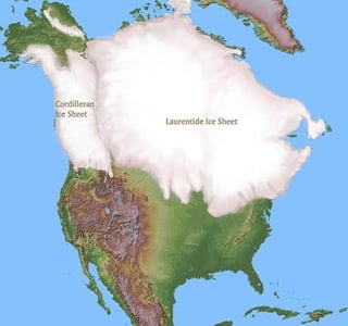
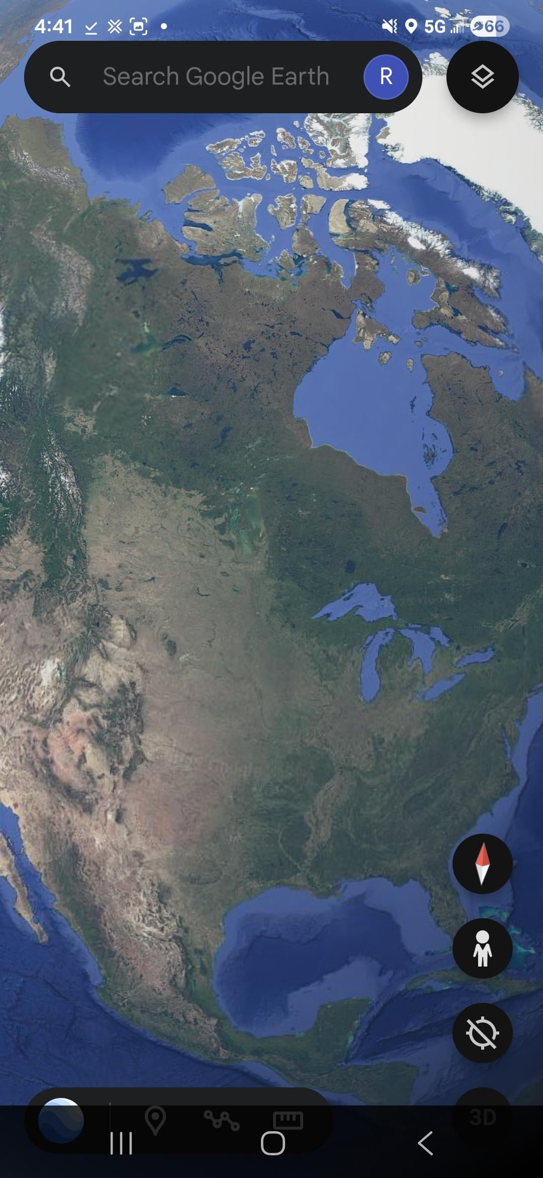
Laurentide dome centered on Hudson Bay; fast-flowing ice streams excavate major troughs, tunnel valleys, and proto–Great Lakes basins.
Sea level ~120 m lower exposes wide continental shelves, letting the ice margin sit on former seabed. This sets up the later ability to cut deep cross-shelf channels during catastrophic drainage.
Evidence: Laurentian Channel architecture, streamlined bedforms, ice-stream corridor mapping.
20–17 ka BP — Deglaciation Onset: Basin Filling & Subglacial Drainage
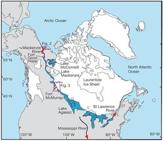
Southern Laurentide margin retreats in pulses, trapping water in massive proglacial basins (Agassiz, Iroquois, early Winnipeg).
Blocked outlets + meltwater input → high, unstable lake stages.
Subglacial sheet floods/tunnel channels develop across the Midwest, depositing large ice-margin sediment complexes.
Evidence: tunnel-channel fans, varved sequences, lake strandlines.
17–15 ka BP — Early St. Lawrence Instability: Repeated Ice Dams
St. Lawrence repeatedly blocked by readvancing ice; lake levels rise until spillways breach or the dam collapses.
Chicago Outlet, Michigan spillways, and eastern channels cut during these overspills.
High-energy pulses shown by coarse-bedload layers and abrupt lake-level drops.
Evidence: stratigraphic jumps, spillway incision geometry, delta-terrace correlations.
14.65 ka BP — MWP-1A: Global Sea-Level Jump, Ocean Forcing
Rapid global sea-level rise (tens of meters on century scales) injects massive freshwater volume into the oceans.
AMOC models and proxy data show sensitivity to this magnitude of freshwater forcing → predisposes the North Atlantic to circulation collapse.
Evidence: coral terraces, δ¹⁸O anomalies, global meltwater-volume reconstructions.
14.6–13.3 ka BP — St. Lawrence Ice-Dam Failures: Major Incision Phase
With the shelf still exposed, the ice margin extends far seaward. Lake Agassiz stands high above paleo-sea level, creating extreme hydraulic head.
Catastrophic dam failures produce hyperpycnal floods capable of:
(a) carving deep cross-shelf troughs,
(b) generating turbidity currents downcutting into slope and Laurentian Fan,
(c) transporting Agassiz sediment signatures far offshore.
Multiple dam readvances re-incise the same troughs, explaining their depth, continuity, and slope overdeepening.
Evidence: Agassiz-sourced detrital layers in Cabot Strait, multiple turbidite cycles on Laurentian Fan, shelf-channel morphology.
Sea-Level Backpressure & Interior Flooding (Concurrent Mechanism)
As MWP-1A raises Atlantic base level, the formerly low shelf outlet loses gradient → flow “backs up.”
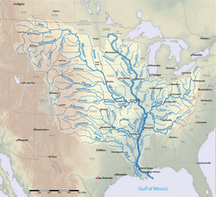
Backpressure shifts drainage toward interior spillways (Mississippi, Ohio, Appalachian lowlands).
Large inland basins show slackwater deposits, broad scours, and reworked alluvium consistent with ponding and redirected catastrophic flows.
Evidence: paleochannel networks, inland turbidites, fine-grained slackwater beds, hydrologic models.
13.3–12.9 ka BP — Flood Maxima: Largest Direct Outbursts
Agassiz reaches highest expanded stage; intermittent St. Lawrence openings release enormous freshwater pulses into the North Atlantic.
These pulses deepen shelf troughs and produce distinct marine turbidite packages.
Evidence: isotopic shifts, graded turbidites, offshore plume deposits.
12.9 ka BP — Younger Dryas Trigger: Compound Forcing
Combined effects:
(1) Global MWP-1A freshwater load,
(2) Repeated proximal Agassiz/St. Lawrence megafloods,
(3) Continued melt flux during warming.
AMOC collapses → abrupt cooling (5–15 °C), widespread hydrologic disruption.
Landscape markers: black mat wetland horizons, Carolina Bays, megafaunal decline, cultural breaks.
Evidence: synchronous stratigraphic transitions across North America; δ¹³C/δ¹⁸O anomalies; ecological turnovers.
12.9–11.7 ka BP — Outlet Reorganization: Final Drainage Architecture
Hudson Bay and St. Lawrence margins oscillate as ice decays.
Michigan/Chicago → Susquehanna/Champlain spillways stabilize; Great Lakes drainage reorganizes northward as rebound begins.
Interior backflooding decreases once the continental shelf submerges.
Evidence: uplifted strandlines, abandoned channels, varve chronologies.
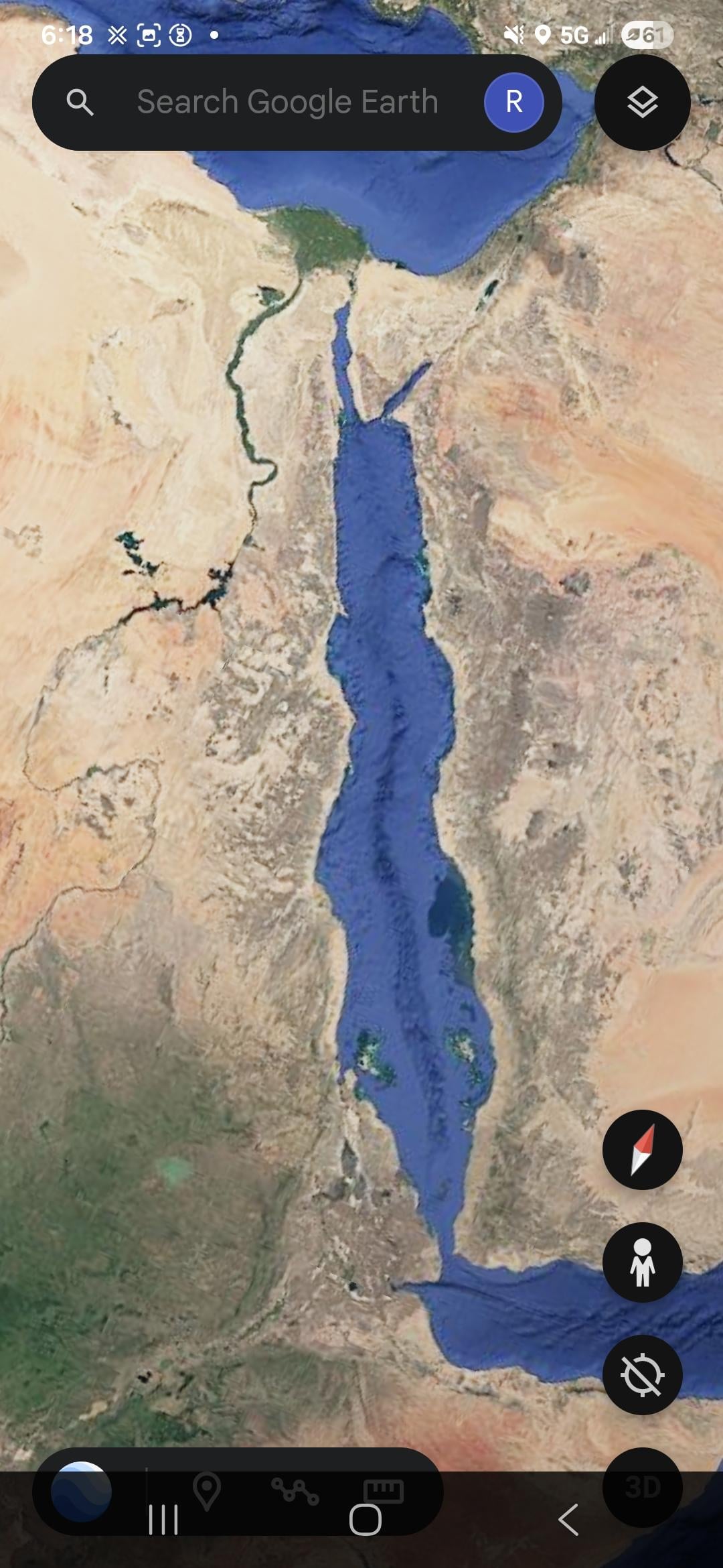
12.9–11.7 ka BP — Red Sea / Bab el-Mandeb Lowstand & Reflooding
Global lowstand narrows Bab el-Mandeb; Red Sea becomes isolated and hyper-saline.
Rapid melt pulses at end-YD abruptly reconnect the basin — enabling fast regional inundation events.
Evidence: bathymetry, salinity proxies, basin-exchange models.
11.7 ka BP — End of Younger Dryas: AMOC Resumption
Circulation restarts; North Atlantic warms abruptly.
Champlain Sea forms over depressed crust; new marine incursion into St. Lawrence.
Evidence: marine shells in Québec basins, rebound-corrected paleo-shorelines.
11.5–10 ka BP — Glacial Rebound & Outlet Migration
Laurentide collapse accelerates; northern outlets rise as rebound tilts the Great Lakes basins.
Shelf drowning buries earlier erosional surfaces under hemipelagic drapes and postglacial turbidites.
Evidence: seismic profiles, buried paleovalleys, rebound curves.
10–8 ka BP — Final Shelf Drowning
Continental shelves fully submerge, locking modern coastal geometry.
Major flood routes shut as sea-level stabilizes.
Evidence: submerged deltas, drowned shorelines, infilled estuaries.
8–7.6 ka BP — Early Holocene Climatic Highs
Caspian mega-highstand, expanded Xinjiang lakes, strong monsoon-driven Sahara “Green Period.”
Subsequent drying marks transition to modern arid belt.
Evidence: beach ridges, lacustrine cores, pollen shifts.
7.6–5.6 ka BP — Black Sea Flood (Mediterranean Overtopping)
Bosporus threshold is overtopped as sea level rises.
Rapid Mediterranean inflow floods the Black Sea basin; human settlements affected.
Evidence: submerged archaeological horizons, salinity jumps, delta reorganization.
6–4 ka BP — Late Holocene Stabilization
Carolina Bays stabilize; Great Lakes settle into final drainage pattern.
Caspian, Xinjiang, and Bonneville remnants adopt modern shorelines.
Evidence: shoreline terraces, aeolian overprints, stabilized dunes.
2 ka BP – Present — Preserved Signatures
Deep shelf troughs (Laurentian Channel, Cabot Strait), thick turbidite packages, inland slackwater sequences, black mat layers, paleochannels, and isotopic freshwater markers remain as the main archives tying the whole sequence together.
by C_B_Doyle
1 Comment
All this stuff about meltwater pulses and amoc collapses might sound very detailed and scientific, but it is probably as wrong and dumb as that tartarian truth bomb mudfloods… The AMOC collapse theory basically says the lack of salt made the whole Arctic cold, how? With bad physics of course… Then they take this wrong idea and overengineer it with detailed “meltwater pulse evidence” they show the whole report and convince themselves.