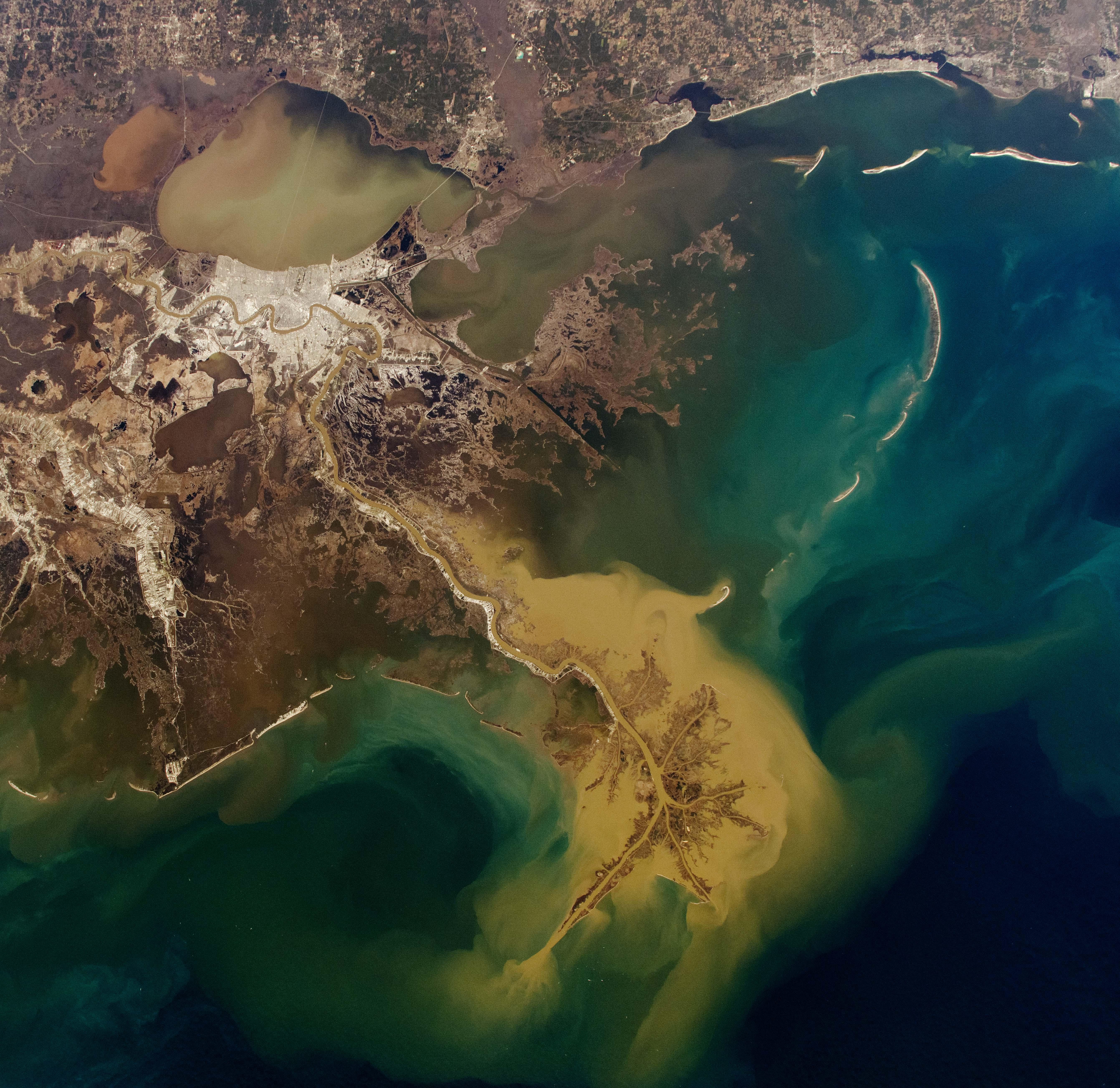
An astronaut aboard the International Space Station captured this photo of the Mississippi River Delta. The river enters the frame from the upper left and winds its way through New Orleans, Louisiana, before fanning out into a delta.
The delta branches out from the river’s mouth into distributary channels, forming the distinctive bird’s foot shape of the Mississippi River Delta Basin (Plaquemines-Balize Delta), before emptying into the Gulf of America (Gulf of Mexico). Light-tan plumes of sediment-laden water extend from the delta, gradually blending into shades of blue as ocean currents disperse the sediments. Between the mainland and the delta’s foot, dark brown-green colors indicate areas of marshland and peat formation. And along the coast, barrier islands—sandbars formed by the receding river delta lobes—are visible, shaped over time by longshore currents and waves that rework the sediments.
A major Gulf Coast storm came through the area between January 20 and 22, 2025. Snow, an uncommon occurrence in this region, still blanketed much of the landscape on the morning of January 24, though most of it had melted away by the afternoon, when this photo was taken. (Some patches may have persisted in urban areas.) The large plume of sediments surrounding the delta was likely influenced by a brief increase in the Mississippi River’s outflow due to the melting of snow.
Originating from Lake Itasca in Minnesota, the Mississippi River flows approximately 3,770 kilometers (2,340 miles) through 10 states before emptying into the gulf. Under natural, unconstrained conditions, a bird’s foot delta is a dynamic landscape where new land grows, channels migrate, and water inundates some areas. The shaping of the delta depends on sediment supplied by the river. However, human intervention, rising sea levels, and ongoing erosion play key roles in the current evolution of the modern Mississippi River Delta.
The Mississippi River’s watershed drains 41 percent of the United States (spanning all or part of 31 states) and reaches into two Canadian provinces. Its nutrient-rich waters support fertile agricultural lands along its shores and throughout the deltaic basin. The river also plays a role in the U.S. economy by providing transportation shipping routes. To maintain these functions, engineers have implemented channelization to help maintain navigable shipping lanes and, in recent decades, launched sediment diversion projects aimed at returning vital sediments to the wetlands.
Flooding from storms and rising sea levels in the low-lying areas surrounding the Mississippi River Delta has prompted flood control measures over the past 200 years, including levees, dams, and floodwalls. Because the Mississippi and its delta remain active geologic forces that reshape the landscape, ongoing modifications are necessary to maintain the navigable passageway.
LastChingachgook on
When the ice begins to melt and you’re too slow to undo your belt…


2 Comments
Image from this post, text from post after the link
[https://eol.jsc.nasa.gov/Collections/EarthObservatory/articles/WinterTransformstheMississippiRiverDelta.htm](https://eol.jsc.nasa.gov/Collections/EarthObservatory/articles/WinterTransformstheMississippiRiverDelta.htm)
An astronaut aboard the International Space Station captured this photo of the Mississippi River Delta. The river enters the frame from the upper left and winds its way through New Orleans, Louisiana, before fanning out into a delta.
The delta branches out from the river’s mouth into distributary channels, forming the distinctive bird’s foot shape of the Mississippi River Delta Basin (Plaquemines-Balize Delta), before emptying into the Gulf of America (Gulf of Mexico). Light-tan plumes of sediment-laden water extend from the delta, gradually blending into shades of blue as ocean currents disperse the sediments. Between the mainland and the delta’s foot, dark brown-green colors indicate areas of marshland and peat formation. And along the coast, barrier islands—sandbars formed by the receding river delta lobes—are visible, shaped over time by longshore currents and waves that rework the sediments.
A major Gulf Coast storm came through the area between January 20 and 22, 2025. Snow, an uncommon occurrence in this region, still blanketed much of the landscape on the morning of January 24, though most of it had melted away by the afternoon, when this photo was taken. (Some patches may have persisted in urban areas.) The large plume of sediments surrounding the delta was likely influenced by a brief increase in the Mississippi River’s outflow due to the melting of snow.
Originating from Lake Itasca in Minnesota, the Mississippi River flows approximately 3,770 kilometers (2,340 miles) through 10 states before emptying into the gulf. Under natural, unconstrained conditions, a bird’s foot delta is a dynamic landscape where new land grows, channels migrate, and water inundates some areas. The shaping of the delta depends on sediment supplied by the river. However, human intervention, rising sea levels, and ongoing erosion play key roles in the current evolution of the modern Mississippi River Delta.
The Mississippi River’s watershed drains 41 percent of the United States (spanning all or part of 31 states) and reaches into two Canadian provinces. Its nutrient-rich waters support fertile agricultural lands along its shores and throughout the deltaic basin. The river also plays a role in the U.S. economy by providing transportation shipping routes. To maintain these functions, engineers have implemented channelization to help maintain navigable shipping lanes and, in recent decades, launched sediment diversion projects aimed at returning vital sediments to the wetlands.
Flooding from storms and rising sea levels in the low-lying areas surrounding the Mississippi River Delta has prompted flood control measures over the past 200 years, including levees, dams, and floodwalls. Because the Mississippi and its delta remain active geologic forces that reshape the landscape, ongoing modifications are necessary to maintain the navigable passageway.
When the ice begins to melt and you’re too slow to undo your belt…