

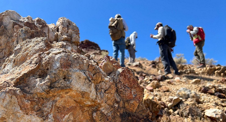
 Geologists recently converged on a site near Barstow, California, to ground-truth a mineral discovery made on public land by a NASA JPL sensor flying aboard a plane overhead. Credit: NASA/JPL-Caltech
A mineral discovery in California’s Mojave Desert is helping scientists investigate whether a porphyry copper deposit may lie beneath a volcanic outcrop, with technology developed at NASA’s Jet Propulsion Laboratory in Pasadena playing a key role in identifying the site.
Geologists from NASA and the U.S. Geological Survey recently traveled to public land near Barstow to examine a concentration of topaz first detected by an airborne imaging instrument. While topaz is known as a gemstone, scientists in this case were interested in it because it can serve as an indicator of porphyry copper deposits, one of the world’s most important sources of copper and other critical minerals.
The field team included three USGS scientists and Robert Green of NASA’s Jet Propulsion Laboratory, the federally funded research center managed by Caltech in Pasadena. Armed with rock hammers, hand lenses and sample bags, the researchers searched for evidence that could help explain the geological history of the area and determine whether the site may overlie a porphyry copper deposit.

“What we’re doing out here is geologic CSI,” Green said as he examined rock samples in the field. “We’re looking for clues to reconstruct what happened here.”
Porphyry copper deposits form when magma and hot fluids move through Earth’s crust, chemically altering surrounding rock. In addition to copper, the deposits can contain critical minerals such as molybdenum and tellurium, materials used in products ranging from steel to solar panels. Geologists often search for topaz because it develops under similar volcanic conditions.
The discovery was made using AVIRIS, the Airborne Visible Infrared Imaging Spectrometer, a remote-sensing instrument developed at JPL. The instrument analyzes reflected sunlight and identifies minerals and chemicals by detecting their unique spectral signatures. Green helped pioneer the technology in the early 1980s, and related versions of the instrument have since been used on missions exploring the Moon, Mars and other planetary bodies.
The latest version, known as AVIRIS-5, recently began operations as part of the NASA-U.S. Geological Survey Geologic Earth Mapping Experiment, or GEMx. The project seeks to identify potential sources of critical minerals across the American West, including in active and abandoned mining regions. Although NASA provides airborne sensing technology and aircraft support, the broader GEMx effort is led by the USGS as part of its nationwide Earth Mapping Resources Initiative, or Earth MRI.
Since 2023, GEMx flights have surveyed more than 386,000 square miles across the United States, including much of California. Scientists use the airborne measurements to identify promising locations for follow-up field investigations, such as the recent expedition near Barstow.
Researchers emphasized that the presence of topaz alone does not confirm the existence of a porphyry copper deposit. While laboratory testing has verified the mineral discovery, determining whether such a deposit exists beneath the site will require more extensive ground-based studies and subsurface investigation.
Still, the find illustrates how advanced remote-sensing technology can help scientists locate previously overlooked geological targets. The finding also demonstrates how airborne sensing can help geologists identify promising targets even in heavily explored parts of Southern California.
“People have been prospecting this area for generations,” said Erik Tharalson, a USGS geologist involved in the project. “But there’s a lot more to discover.”
The mineral-mapping campaign also relies on NASA’s ER-2 high-altitude research aircraft, operated from the agency’s Armstrong Flight Research Center in Edwards. To support the 2026 campaign, the aircraft deployed March 31 from Edwards to Colorado Springs, Colorado, allowing researchers to maximize data collection across Colorado, Utah, New Mexico, Arizona and Texas. Flying at roughly 65,000 feet, the aircraft can collect detailed spectral measurements across large areas in a single pass. During the deployment, which concluded June 5, the aircraft completed 26 flights totaling more than 125 hours.
NASA said the ER-2 flew 36 science missions in 2025, collecting more than 7 billion measurements during more than 200 flight hours. Those observations contributed to what the agency described as the largest airborne surface mineralogy dataset gathered in a single NASA-USGS campaign.
The GEMx survey is led and funded by the USGS Earth Mapping Resources Initiative, which is working to modernize mapping of the nation’s surface and subsurface to identify critical mineral resources. The initiative involves partnerships with 45 state geological surveys, federal agencies, private industry, tribes, universities and other organizations. According to the USGS and NASA, the effort combines NASA-developed spectroscopic imaging technology with USGS expertise in field geology, mineral analysis and resource assessment.
For Pasadena-area residents, the project highlights another Earth-science application of technology developed at JPL. While the laboratory is best known for robotic exploration of Mars and the outer solar system, its imaging and remote-sensing instruments also support research closer to home, including efforts to better understand the geology and mineral resources of the American West.
![]() Get our daily Pasadena newspaper in your email box. Free.
Get our daily Pasadena newspaper in your email box. Free.
Get all the latest Pasadena news, more than 10 fresh stories daily, 7 days a week at 7 a.m.