

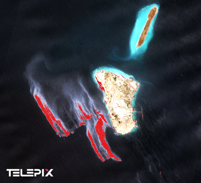
Detection result of an oil slick near Kharg Island from an optical image captured by the European Space Agency’s (ESA) Sentinel-2 satellite at 7:16 AM on May 6, 2026. Spectral reflection characteristics typical of a thick oil layer were identified in the sea southwest of Kharg Island, with the suspected oil area marked in red. Courtesy of TelePIX.
TelePIX, a South Korean space artificial intelligence (AI) solutions company, has identified a potential oil slick in the waters near Kharg Island, Iran’s key crude oil export terminal. The company also presented a seven-day drift forecast, predicting the slick will move and spread to the southeast.
TelePIX announced on the 12th the results of its analysis of satellite imagery of the waters near Kharg Island taken on the 6th.
TelePIX cross-analyzed the anomalous area using data from the European Space Agency’s (ESA) Sentinel-1 Synthetic Aperture Radar (SAR) and Sentinel-2 optical imagery, as well as sea wind data from Europe’s MetOp ASCAT satellite and the Hybrid Coordinate Ocean Model (HYCOM).
In the Sentinel-1 SAR imagery from 2:41 PM on May 6, a reduction in the sea surface reflection signal, a common characteristic of oil layers, was observed. The analysis showed that the backscattering coefficient, which measures radar reflection intensity, was 25 decibels (dB) lower than the surrounding sea surface. The company explained this is due to “sea surface smoothing,” where the oil film on the water’s surface dampens waves.
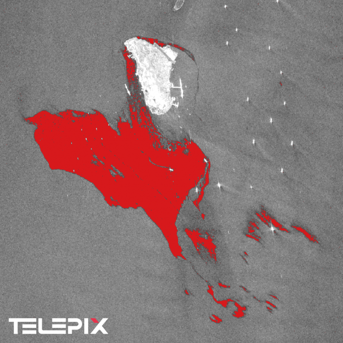
Detection result from a Synthetic Aperture Radar (SAR) image of an oil slick near Kharg Island, captured by the European Space Agency’s (ESA) Sentinel-1 at 2:41 PM on May 6, 2026. The area with a reduced backscattering coefficient due to sea surface smoothing by the oil slick is marked in red, southwest of Kharg Island. This image, taken about 7 hours after the optical image, confirms the oil slick’s movement in a southeastern direction. Courtesy of TelePIX.
At 7:16 AM on May 6, the Sentinel-2 optical imagery showed a reflection pattern characteristic of a thick oil layer in the same location. This is a feature where oil reflects light more strongly than the sea across various light bands.
TelePIX explained, “The wind speed in the area at the time was confirmed to be over 8 m/s, making it unlikely that a natural phenomenon occurring in calm wind conditions was mistaken for an oil slick.”
Analysis of the ocean numerical model showed a weak northwesterly sea current between 6 AM and 9 AM, followed by a southward flow from 9 AM to noon, and a strengthening southeastern flow from noon to 3 PM. This aligns with the direction of the slick’s movement between the Sentinel-2 and Sentinel-1 observation times.
TelePIX also predicted the oil slick’s movement path for the next seven days using a simulation based on a ‘Lagrangian particle tracking model.’ This method analyzes the dispersion path by assuming the oil spill point consists of hundreds of independent particles and tracking their movement on an hourly basis, reflecting the influence of currents and wind. The results indicated a high probability that the oil slick will move and spread toward the southern part of the Persian Gulf, carried by ocean currents and wind.
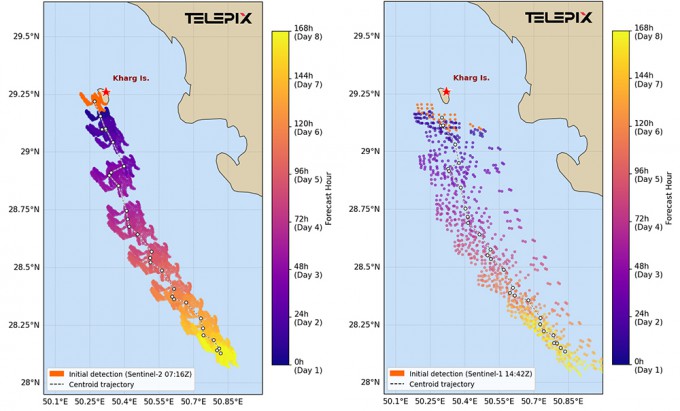
Predicted 7-day movement path of the oil slick based on Sentinel-2 detection results (left) and Sentinel-1 detection results (right). The color change from blue to yellow indicates the path over time, both consistently concluding that the slick will move and spread toward the southern Persian Gulf. Courtesy of TelePIX.
Kwon Darongsae, Chief Data Scientist at TelePIX, stated, “Features of the same location and shape were simultaneously confirmed in both SAR and optical imagery, and these findings were consistent with the wind speed and sea current analysis. This allowed for a scientific prediction that reflects actual physical phenomena, going beyond simple image interpretation.”
She added, “As Kharg Island is a key crude oil export hub for Iran, this analysis is significant as a case of rapidly detecting and analyzing anomalies related to the global maritime and energy supply chain on a satellite basis.”
TelePIX plans to quantify the affected area and the scale of the spill through further analysis and to enhance the accuracy of its oil slick movement and dispersion predictions. The company also intends to continuously monitor the time-series changes and spread of the oil slick, primarily using its self-developed and operated AI cubesat, BlueBon.
Copyright ⓒ DongA Science. All rights reserved.