
I posted this about the Cochno Stone 10 months ago and most people dismissed it.
Now I want to revisit it, because there’s more discussion, more comparisons, and more people actually paying attention.
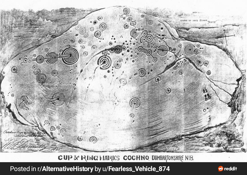
I’ve been diving into the Cochno Stone in Scotland, and something about it feels much bigger than what’s commonly believed.
The Cochno Stone is a massive 5,000-year-old rock near Clydebank, covered in cup and ring marks, spirals, grooves, and geometric shapes. Mainstream archaeology sees it as ritual or possibly astronomical, but what if it’s more than that?
There’s a cross-like symbol that could correspond to Scotland’s position on a world map. Then there’s a massive ring pattern that seems to align eerily well with the Richat Structure in Mauritania, which some have linked to Atlantis.
What really stands out is how other ringed or significant ancient sites seem to line up. Easter Island in the Pacific, Tiwanaku and Puma Punku in Bolivia, Sigiriya in Sri Lanka, the Yonaguni underwater structure in Japan, the Bosnian Pyramid Complex, the Giza Plateau in Egypt, and Stonehenge. Even the Azores Islands in the Atlantic come into play, especially with reports of pyramid-like structures and their position in the middle of the ocean.
Now here’s where it gets interesting.
If this is some kind of world map, it might not look accurate to us because we’re expecting a modern projection. What if they used a completely different way of mapping the Earth? Or what if this wasn’t drawn directly from observation, but from memory?
If knowledge was passed down after a major catastrophe, over generations details would degrade. Just like if you asked someone today to redraw a world map purely from memory, it wouldn’t be perfect. Now imagine that process stretched over thousands of years.
What we might be looking at isn’t a precise map, but a remembered world. A distorted, symbolic reconstruction of a lost geography, possibly from a much older global civilization.
And that’s the part people missed before.
Instead of asking why it isn’t exact, the better question is why there are similarities at all.
I’m bringing this back because I want a better discussion this time. Not instant dismissal, but not blind belief either.
If the Cochno Stone is some kind of map, even a distorted one, do any of the carvings actually match real world locations?
I’ve already noticed possible alignments with places like the Richat Structure, Stonehenge, and Giza, but I know there are many more megalithic or ancient sites out there that I might be missing.
Are there any sites you know, especially ringed structures, pyramids, or unusual formations, that seem to line up with the patterns on the stone?
Even partial matches matter. If this was based on memory, a different map projection, or knowledge passed down over time, then we shouldn’t expect perfect accuracy, just consistent patterns.
I’m open to being wrong, but I want to test the idea properly this time.
What do you see?
by Fearless_Vehicle_874
7 Comments
Last time I saw something about this I posted about how it was similar to the Judiculla stone ( not sure I spelled it right!) In NC. It has ancient markings that look almost EXACTLY the same.
The Cochno Stone leaves the Indian Ocean and South Atlantic blank not because the mapmaker didn’t know better, but because these oceans were empty, just as they are today: no civilizations, no cities, nothing worth mapping. At the same time, some megalithic sites and minor settlements are missing, while major centers are clearly marked. If the world ended today and someone tried to draw a map from memory, they’d likely record only the largest cities and countries, forgetting the small, remote, or “insignificant” ones. The Cochno Stone, then, may be a memory-based record selective, skeptical, and focused on what truly mattered.
Only around 20 minutes away from it but never visited.
It easily could be a map, that’s one of the best theories for it. But why would we jump to it being a map of the world? That would be, by far, the most unlikely type of map that this would be.
It would be the most difficult map to make while simultaneously being the least useful.
Think about it like this.. we have thousands of old maps. Some even as old as this thing. Rocks, tablets, scrolls, you name it. 99.99% of them are maps of an area less than 10-15 square km.
Just because these guys have a cool art style doesn’t make this one any likely to be different.
No.
It looks more like it’s a star map. The greater amount of things around a dot look light they could be a way of indicating a brighter star, while the dot/circles connected by lines are constellations or an equivalent.
I mentioned this stone to a family member a while back, we agreed the logical purpose was a map. So I am open to your hypothesis.
However I assume the map more related to the British and European terraine, most likely just Britain and maybe Ireland and some northern parts of the continent at most, or regional to that location.
One thing about the symbols, they may describe activities that are time dependent.
Scottish megalithic alignments are more lunar, which hints either at fertility or more practically, to tidal factors and measuring time. Its important as I can imagine locals migrated quite a bit seasonally and took advantage of different food sources. Tides are important for coastal and estuaral navigation.
We know people from the Orkneys travelled down to Stonehenge, apparently in winter.