

I've spent the last month running formal statistical tests on the great circle alignment — the claim that ancient sites from Giza to Nazca to the Indus Valley sit on a single line around the Earth. Eight unique databases, over half a million ancient sites. Every alternative explanation I could think of.
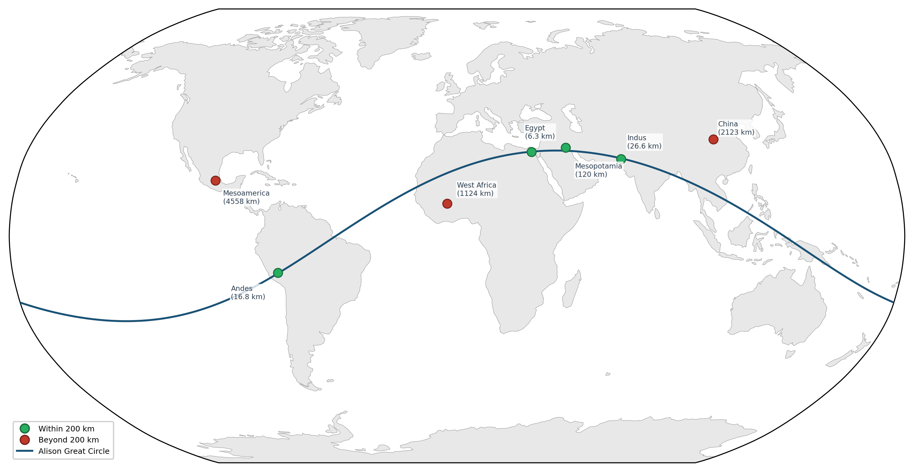
Green dots on the map:
- Egypt (6.3 km from the circle).
- Andes (16.8 km). Indus Valley (26.6 km).
- Mesopotamia (120.2 km).
Red dots:
- China, Mesoamerica, and West Africa miss.
I generated 100,000 random great circles. Only 42 connected four or more of these seven independently originated civilizations. That's p = 0.00042. (1 in 2,400)
The explanation is geological. The circle traces Earth's densest belt of desert-river interfaces – places where rivers cut through deserts, creating the circumscribed environments that force civilizations to emerge. 29 arid-fertile rock transitions along the circle vs. 4.5 for random circles (p < 0.0001). Less than 1 in 10,000.
The three that miss emerged under different conditions.
- China: steppe-bounded.
- Mesoamerica: jungle-bounded.
- West Africa: savanna transition.
The geology predicts the hits and the misses.
One unexpected finding from the same research: while testing navigation routes using the same geodesic mathematics, 10 of 14 pre-industrial long-distance paths – including routes across the Australian desert, Polynesian star paths, and a pre-Columbian trail through North American forest – follow geodesic arcs at precision exceeding 95% of random paths.
Full paper submitted to the Journal of Archaeological Method and Theory.
Preprint: https://doi.org/10.5281/zenodo.19240285
Globe: https://thegreatcircle.earth
by tractorboynyc
6 Comments
OkayGPT
Great circle theories have been consistently debunked. You can make a great circle out of anything you like, it’s just random geometry. Do try harder.
Nazca isn’t the cradle of Andean civilization, not by thousands of years. The oldest complex ruins in the Andean region are about four degrees north and three and a half millennia earlier.
I’m still blown away by this and need to speak up so someone can either shut me up or agree…
Because of the scale of this diagram/map… the line we’re talking about is literally 100-150 miles wide. And even with that, the cities don’t line up directly on the line.
If they could have, they would have. Why did they choose to just “estimate” where they put their city?
The distance from these sites and this line could vary anywhere from 1-150 miles off. That’s hours of driving in a car. Again… if they could have done it, they would have, so why are they off by so much?
On what basis did you plot the precise geographical location of the origin of these societies, such that you could measure their precise distance from your great circle?
I saw this Indiana Jones Game. The circle allows you to teleport.😆