

THE CORE IDEA
A sophisticated human civilization existed during the last Ice Age when sea levels were 400 feet lower. They built the megalithic structures we call "ancient." They understood plasma physics, acoustic engineering, and clean energy. They tracked astronomical cycles to predict catastrophic climate events.
They didn't disappear in one event. They got knocked back five times over 12,000 years — each time losing more knowledge, more population, more infrastructure.
THE CATASTROPHE TIMELINE
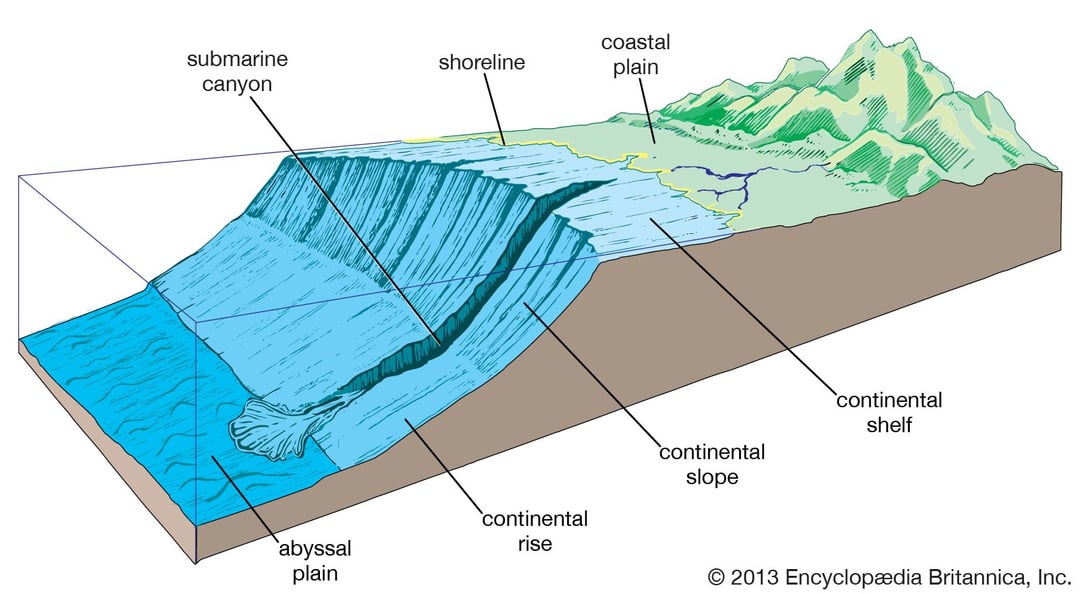
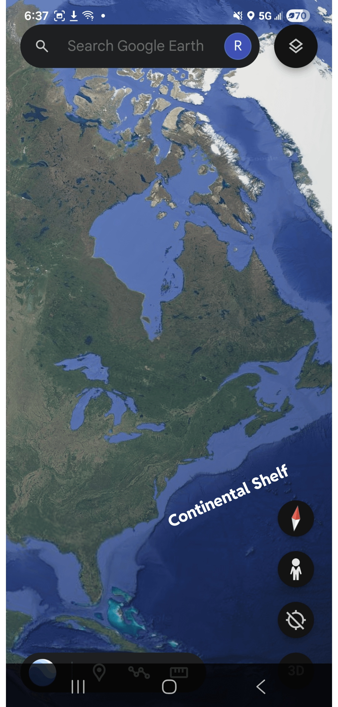
20,000 BC — Ice Age peak. Sea levels 400ft lower. Continental shelves exposed. The Sahara is green and networked by rivers the size of the Nile. Civilization at its peak on coastal land that is now underwater.
14,600 BC — Meltwater Pulse 1A. The Laurentide Ice Sheet starts collapsing and cascades globally. Sea level jumps 20-25 meters in under 500 years. First coastal cities drown. Builders retreat to highlands.
12,900 BC — The Younger Dryas. Cold freshwater hits the North Atlantic and kills the Atlantic ocean conveyor (AMOC). Temperature drops 8°C in 3 years. A 1,200 year winter follows. Mammoths, mastodons, horses, camels — all gone. Megalithic construction stops worldwide. The unfinished stones with their lifting nubs still attached are the physical signature of this exact moment.
11,700 BC — AMOC restarts. Survivors emerge. Göbekli Tepe is built — not a temple, a survival monitoring station tracking the celestial indicators that preceded the last catastrophe. They're watching the sky to know when the next one is coming.
10,000–8,500 BC — African Humid Period. The Sahara briefly greens again. The Sphinx is built or substantially refaced during this window. The deep vertical rainfall erosion on the Sphinx enclosure walls — documented by Boston University geologist Robert Schoch — is only consistent with this wet period, not the dry desert Egypt has been for 5,000 years.
8,200 BC — The Hudson Strait Blowout. Lake Agassiz, a glacial lake larger than all the Great Lakes combined, drains subglacially. 163,000 cubic kilometers of cold freshwater blasts through Hudson Strait into the North Atlantic in approximately 6 months. That's 25 Amazon Rivers simultaneously. AMOC collapses again. A civilization already weakened by the first event can't survive the second. Göbekli Tepe is abandoned at exactly this moment.
6,000–4,000 BC — The Sahara desiccates. Survivors follow drying riverbeds eastward to the Nile Valley. They find the pyramids already standing. They don't know who built them. They build their entire civilization and religion around structures they inherited and don't understand.
3,000 BC — Dynastic Egypt "begins." They didn't build the pyramids. They found them.
THE PHYSICAL EVIDENCE
Sphinx water erosion — Deep vertical weathering channels on the enclosure walls consistent with heavy prolonged rainfall. Last time Egypt had that rainfall: 7,000–10,000 BC minimum. That's 5,000 years before conventional Egyptology says it was built. The head is also disproportionately small for the body — it was recarved by Egyptians who found it, weathered it down, and put a pharaoh's face on someone else's monument.
The nubs — Megalithic stones at Giza, Baalbek, and Puma Punku all have unremoved lifting bosses — protrusions used during transport, normally chipped off during final placement. They were never removed. Construction was interrupted and never resumed. Same pattern. Multiple continents. Same moment in time.
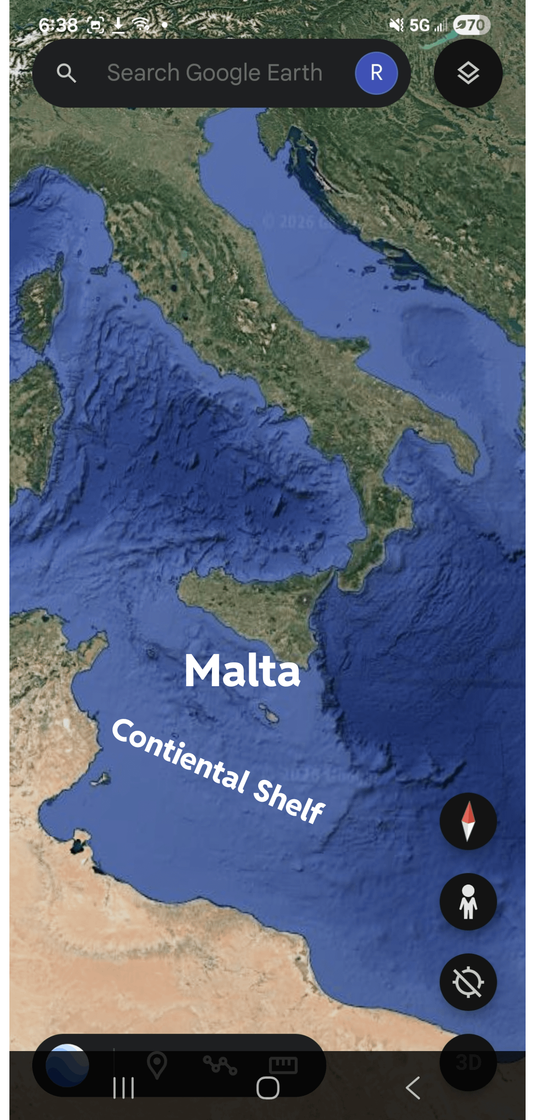
Cart ruts running into the sea — Malta. Ancient cart ruts carved into bedrock extend off cliff edges directly into the Mediterranean. They don't stop at the cliff. They continue underwater. They were carved when the sea level was lower. Direct physical evidence of a pre-flood civilization using land that is now submerged.
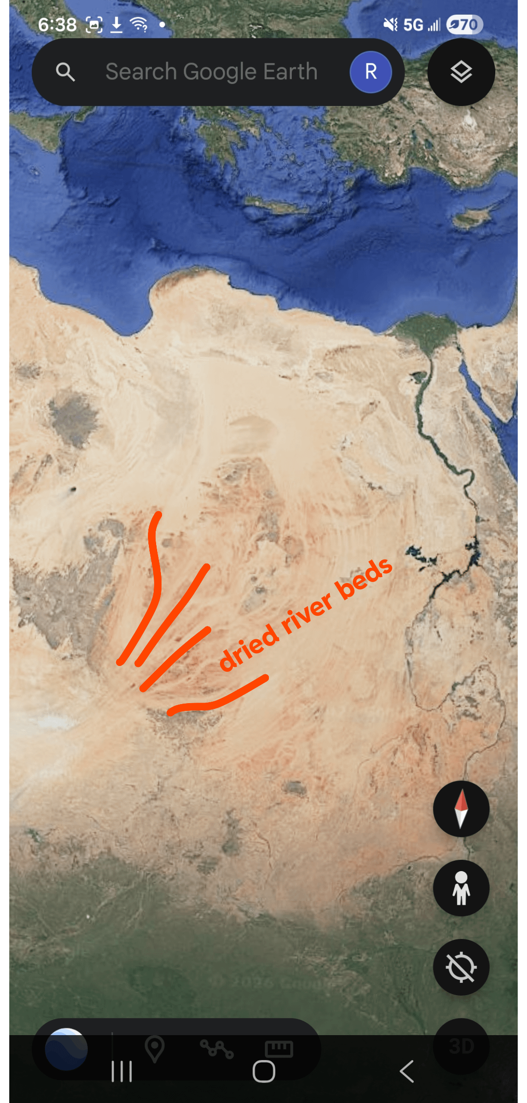
The Saharan river network — Satellite radar has revealed ancient riverbeds under the Sahara the size of the Nile. Mega Lake Chad once covered an area larger than California. Over 2,400 archaeological sites line one dried river alone. The entire Sahara was a green, populated, river-networked landscape. Giza sits at the eastern terminus of this network — optimal position for a primary site needing water transport and aquifer access simultaneously.
Acoustic engineering — The Grand Gallery of Giza, the Malta Hypogeum, and Derinkuyu underground city in Turkey all show precision-engineered acoustic resonance. Same technical tradition. Three different continents. This is not coincidence — it's a shared knowledge base.
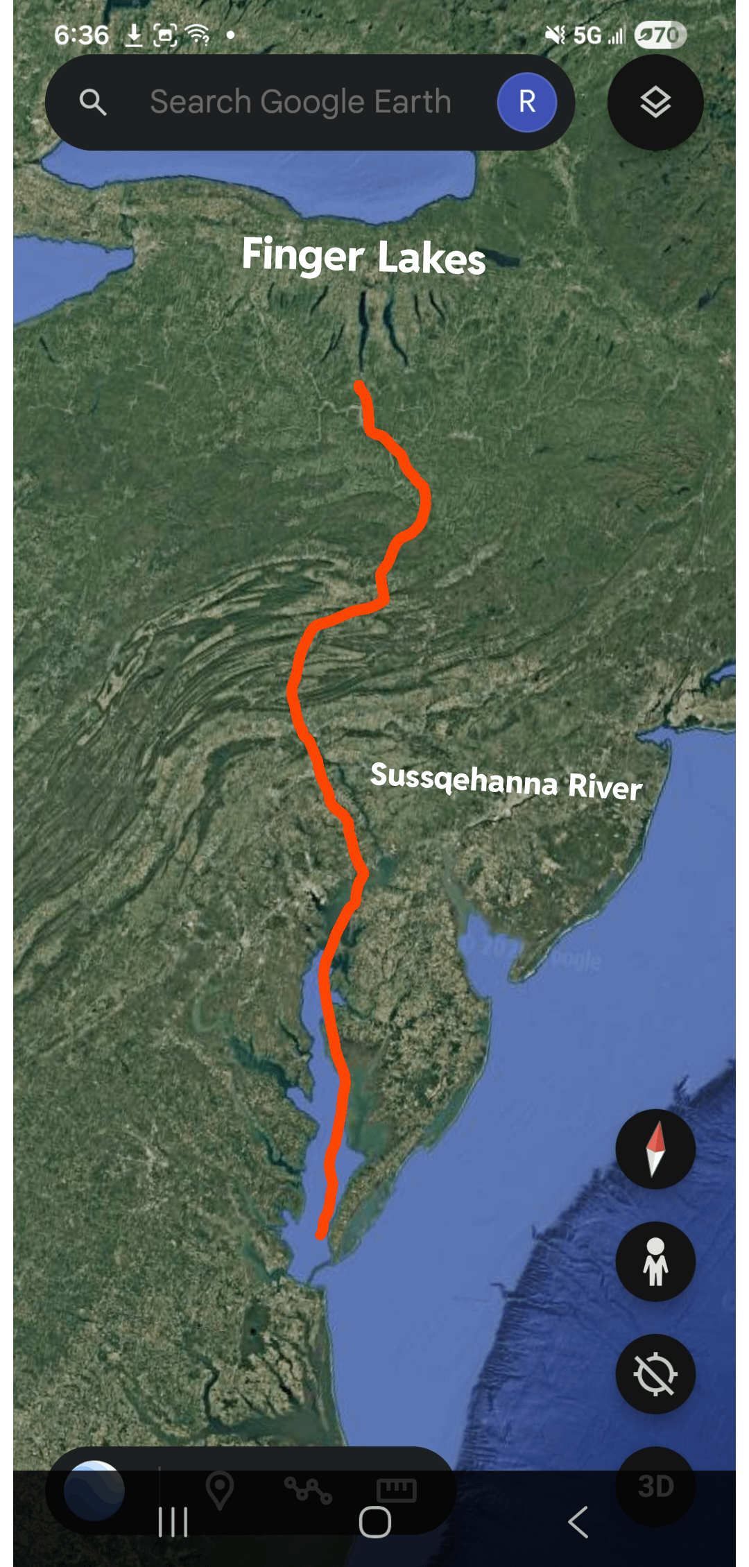
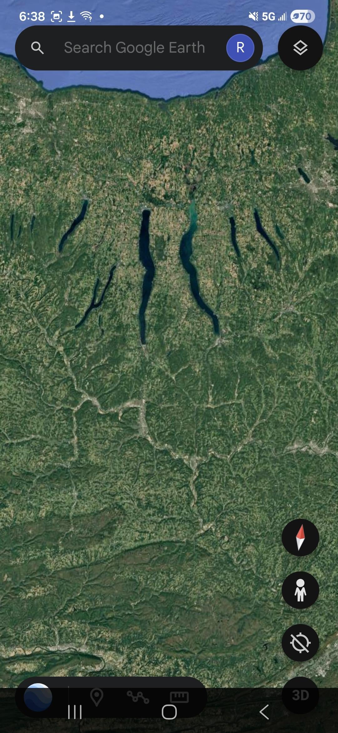
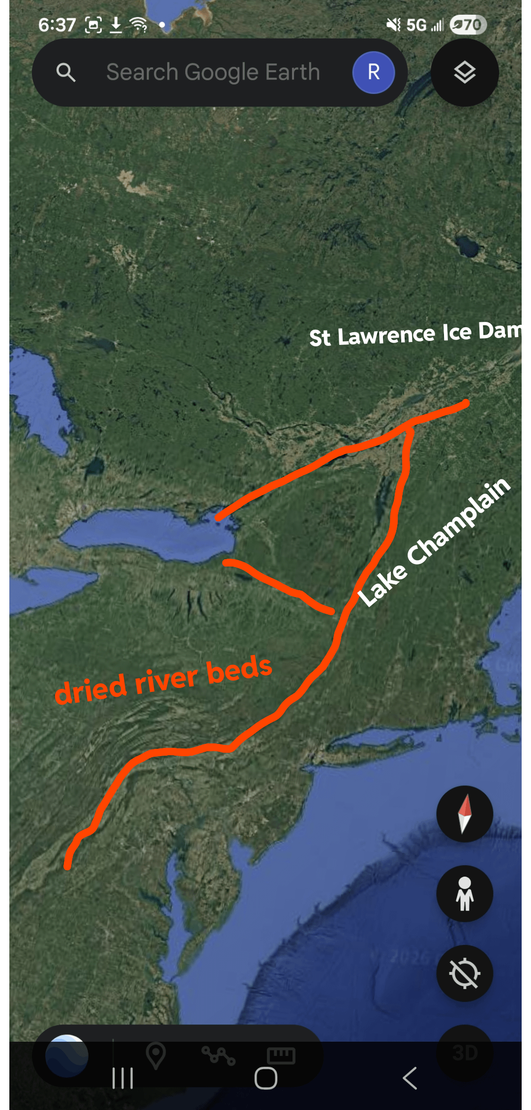
The Susquehanna / Finger Lakes / Carolina Bays — The St. Lawrence was blocked by the ice sheet so all Great Lakes meltwater got forced south through the Champlain Valley and down the Susquehanna. The Susquehanna is older than the Appalachians — which is why it cuts straight through mountain ridges in near-straight lines rather than going around them. That's not a normal river. That's a flood corridor. The Finger Lakes are the scoured-out remains of that drainage — valleys deepened to 600+ feet, some bottoming below sea level. The Chesapeake Bay is just the drowned mouth of the ancient Susquehanna. The Carolina Bays — 500,000+ elliptical depressions covering the entire eastern seaboard — sit directly downstream of all this, contemporaneous with the 12,900 BC Younger Dryas boundary. The entire eastern seaboard from New York to Florida is one continuous flood scar from a drainage system that no longer exists.
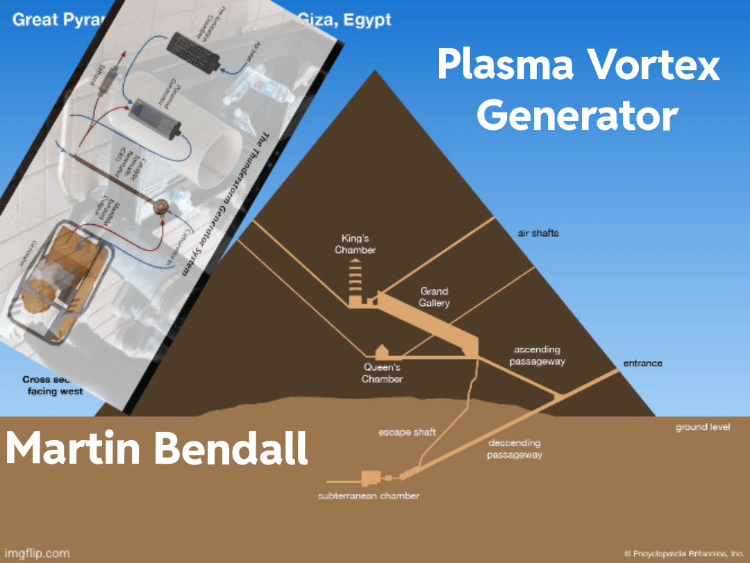
THE TECHNOLOGY — GIZA AS PLASMA VORTEX GENERATOR
This is speculative but physically grounded.
Malcolm Bendall built a working device that mimics thunderstorm dynamics — ionizes air, creates a self-organizing toroidal plasmoid, outputs cleaner air and potential hydrogen enrichment. Real device. Real physics.
Randall Carlson documented that the slope angle of the Great Pyramid — 51.83 degrees — is the geometry at which anomalous self-sustaining plasma behavior occurs. The system crosses a threshold and becomes self-perpetuating.
The pyramid's internal geometry maps onto a scaled version of this system:
- Grand Gallery as ionization and resonance chamber
- King's Chamber (granite with 20-30% quartz, genuinely piezoelectric) as the plasmoid formation zone
- Shafts as gas flow and ion exhaust regulators
Ignition: One lightning strike to the metal capstone. Megavolts delivered instantly. Plasmoid initiates. Crosses the 51.83-degree threshold into self-sustaining mode. Runs on ambient atmospheric electricity — 300,000 volts between ionosphere and ground at all times. No fuel. No waste. 100% clean.
Output: Ionized air. Possible hydrogen generation. Possible monatomic gold production as a plasma byproduct from mineral-rich aquifer water cycling through the hydraulic system below.
Why no physical residue: A plasmoid contained by geometry leaves no more trace than wind in a tunnel. The absence of evidence is consistent with the technology, not evidence against it.
THE MONATOMIC GOLD CONNECTION
Every ancient culture. Independently. Always associated with a priestly knowledge class and abilities that shouldn't be physically possible.
- Egyptian pyramid texts: mfkzt powder — associated with the gods
- Mesopotamian texts: shem-an-na
- Hebrew texts: manna
- Alchemical tradition: the Philosopher's Stone
David Hudson accidentally rediscovered this material in 1975. In superconductive state it loses approximately 44% of its weight. He filed patents. Then disappeared.
The implication: Even a 40% weight reduction on an 800-ton stone makes it a 480-ton stone — suddenly within range of organized human labor. The "magic" of the builders was applied quantum chemistry. The priestly class that understood it guarded it as the most valuable knowledge on Earth.
THE RETREAT SEQUENCE
The civilization didn't collapse — it retreated progressively as conditions worsened.
- Coastal shelves → rising water → flee to highlands
- Highland mega-structures → Giza, Baalbek, Puma Punku → Younger Dryas hits
- Caves → not primitive, just cold. Chauvet cave paintings show perspective and anatomical accuracy not supposedly achieved again until the Renaissance. These are sophisticated people in survival mode.
- Highland monitoring stations → Göbekli Tepe — watching the sky for warning signs
- Underground cities → Derinkuyu — 18 stories deep, 20,000 people, ventilation, livestock, wells. Built in advance by people who knew what was coming.
- Fragments → scattered survivors emerge, knowledge degraded to myth, become dynastic Egypt and Sumer
THE CHAMPLAIN SEA — BELUGA WHALES IN VERMONT
This one is just wild and completely real.
When the ice dam blocking the Champlain Valley finally broke, the land was still depressed below sea level from the weight of the glacier. The Atlantic Ocean flooded in through the St. Lawrence — creating an inland sea covering Vermont, New York, and Quebec. Beluga whales, walruses, Atlantic cod, and seals lived in what is now landlocked Vermont.
In 1849 railroad workers found a beluga whale skeleton in Charlotte, Vermont — now on display at the University of Vermont. This sea existed from roughly 12,000–10,000 BC then the land slowly rebounded and the water drained — leaving Lake Champlain as the remnant.
The builders living through this watched the Atlantic Ocean fill their valley in real time.
THE CONCLUSION
The history of human civilization is not a straight line from primitive to advanced. It's a cycle — repeatedly interrupted by catastrophes that reset the counter.
The pyramids were not built by dynastic Egyptians with copper tools. The Sphinx was not built in 2,500 BC. Göbekli Tepe was not a primitive hunter-gatherer temple. These are the remnants of a civilization that understood plasma physics, acoustic engineering, aquifer hydrology, and astronomical prediction — developed over thousands of years of Ice Age cycling — and lost almost everything in a geological instant when two consecutive AMOC collapses within 4,700 years ground it to nothing.
What we call ancient history is the recovery. What we call mythology is the memory. What we call religion is the fragmented technical manual of a civilization we have not yet found.
Where is the physical evidence? Under 200-400 feet of water on continental shelves worldwide. We haven't looked. That's where to start.
by C_B_Doyle
6 Comments
Did this civilization have ceramics or other materials that would be well preserved over time?
Anything is possible. But this advanced ice shelf civilization would have had to not move inland and not trade with anyone.
Sea level rise was very slow, over hundreds and thousands of years as you note. Why do we simultaneously think we are underestimating these coastal/maritime groups but then imply they just sat there while they, and every possible trace of their existence, was slowly swallowed? It doesn’t make sense. It’s a convenient hypothesis that explains the lack of evidence, but that’s about all we can get from it.
More AI slop by someone who just discovered things scientists have been talking about for 50 years.
Ah yes, the superior civilization that had amazing technology but never saw higher water levels coming…
Many known coastal cities of antiquity are underwater as we speak. It’s not just possible but likely an entire civilization(s) has been lost to history under the waters or time. This is most likely where the kernel of truth comes from regarding the Atlantis story.
I believe within my lifetime we will get a legit opportunity to dive down, picture and study the structures found off the coast of Cuba. If I remember correctly one such structure was a pyramid as well. This could be a lost civilization as the last time the area was above water was from the last ice age up to 50,000 years ago.
With the way the relationship between Cuba and the USA has been deteriorating, for the communist, anti-American, dictators in charge anyway, it may soon be a free country for those who have been forced to live there. This change would make the door wide open for investigating this lost civilization. The people freed and human history possibly being rewritten, it’s a win win.
Native Americans stand by 50000 years or more.