

This is all speculation and I am not an expert in any of this.
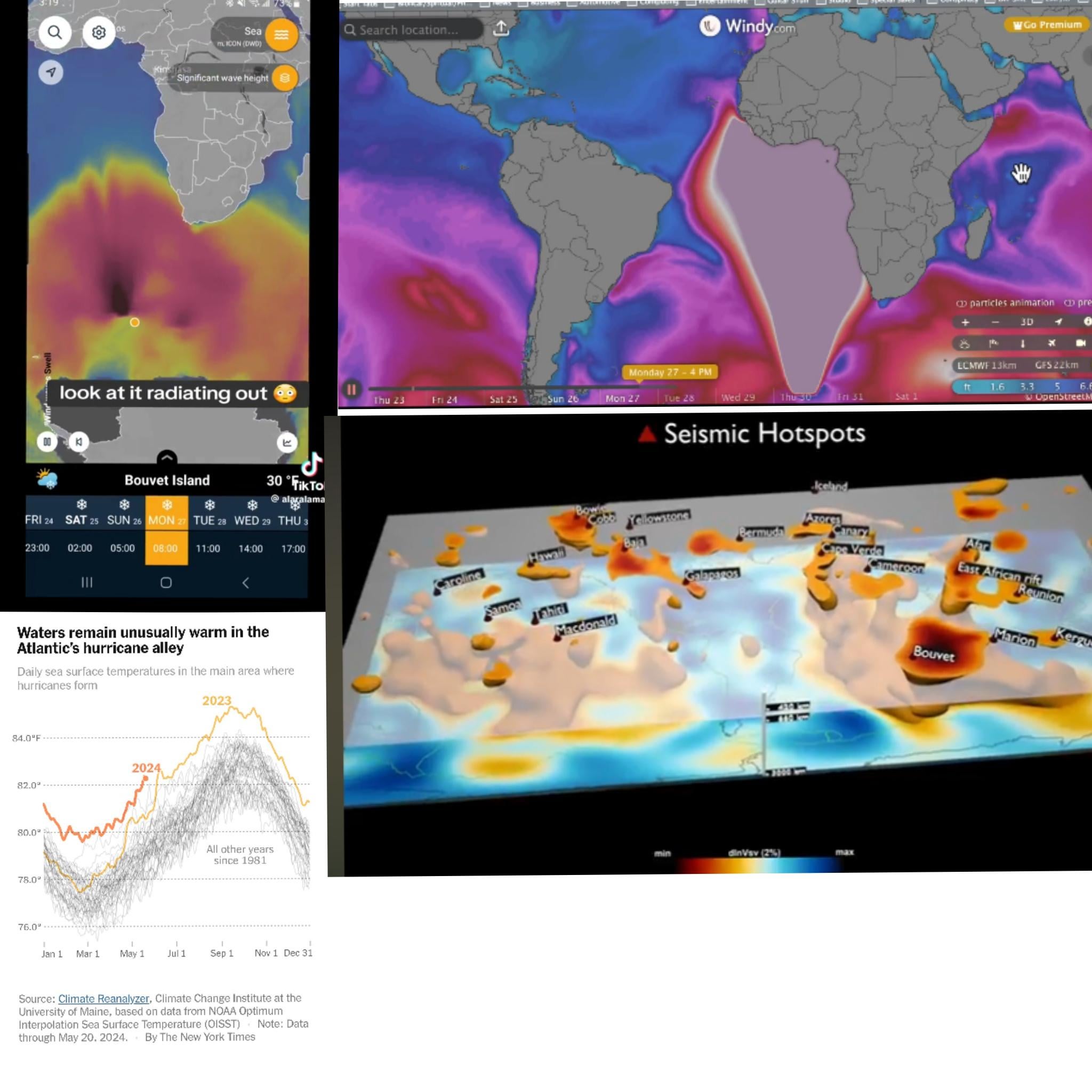
So both windy.com and Ventusky use a German system called ICON, specially ICON 13. Deutscher Wetterdienst (DwD)’s ICON models used by Ventusky, [Windy.com](http://windy.com/), and other weather sites display future weather and climate predictions based on real-time data that is updated every few hours. My fun little theory is that if the ICON 13 systems are picking up massive seismic activity in that area, it will model a future predicted path over the next few hours or days based on the initial data readings picked up that moment. ICON13 may be recording a massive seismic event that only takes place in the regions around Bouvet Island, but ends up modeling a massive ‘wave’ anomaly prediction that extends all the way up the coast of Africa due to the fact it’s misinterpreting the local seismic event as a massive ‘wave’ extending up from the origin point. But once the real-time data is updated a few hours later, the seismic activity may not be occurring at that time; hence the blob anomaly disappearing. So it’s kind of a ‘glitch’ since ICON isn’t meant to model massive seismic activity data readings.
Back in the 1820s, another island about 44 miles off the cost of Bouvet Island was discovered and named Thompson Island. It was seen a few times, with the last recorded sighting in 1894. In 1898, it “disappeared”. The disappearance was theorized to be due to a massive submarine volcanic eruption that collapsed the island, but it was never confirmed. As technology advanced throughout the years, the depth of the location was calculated to more than 2400 m, making the existence of the island highly improbable. BUT: a paper titled “A high-altitude snow chemistry record from Amundsenisen, Dronning Maud Land, Antarctica” Published online by Cambridge reports that “Temporal variations in sea salts are thought to be associated with changing intensity in surface wind speeds near the ocean surface (e.g. Reference Petit, Briat and RoyerPetit and others, 1981). The temporal variability of the sea-salt species through this record is not large, except for several high concentration spikes through the 1880s and 1890s, (Fig. 3). The most pronounced peaks appear during the winters of 1894 and 1895, and coincide with the Thompson Island eruption which is believed by Reference LambLamb (1967) to have occurred in 1895–96 at high southern latitude (54° S, 5° E). This eruption is thought to have destroyed an island and most likely injected large amounts of sea salts into the atmosphere.”
What makes this specific location around Bouvet Island wild is the insane phenomenon going on under Earth’s crust beneath the region around Bouvet Island and off the coast of Africa. The location of Bouvet and Thompson Islands are found above something called the African large low shear velocity province. This is a characteristic structure of parts of the lowermost mantel, the region surrounding the outer core deep inside the Earth. The African LLSVP extends laterally for thousands of kilometers and possibly up to 1,000 kilometres vertically from the core-mantel boundary. The African LLSVP is so massive it is speculated by scientists to be a potential cause for the South Atlantic Anomaly: a massive ‘hole’ in Earth’s magnetic shield
by thr0wawaytea