

I came across what I believe might be the map Luigi Vendittelli referenced on the Rogan podcast (https://www.youtube.com/watch?v=Lb\_1d68vx-g&t=9613s). I’m not 100% certain this is the exact map he was referring to, but the more I study it, the more it lines up.
I did send him a message on IG asking for confirmation. Though I didn't get a formal response, he did "love" my message and the link to the map… take that for what it's worth.
You can download for free here: https://store.usgs.gov/product/527930
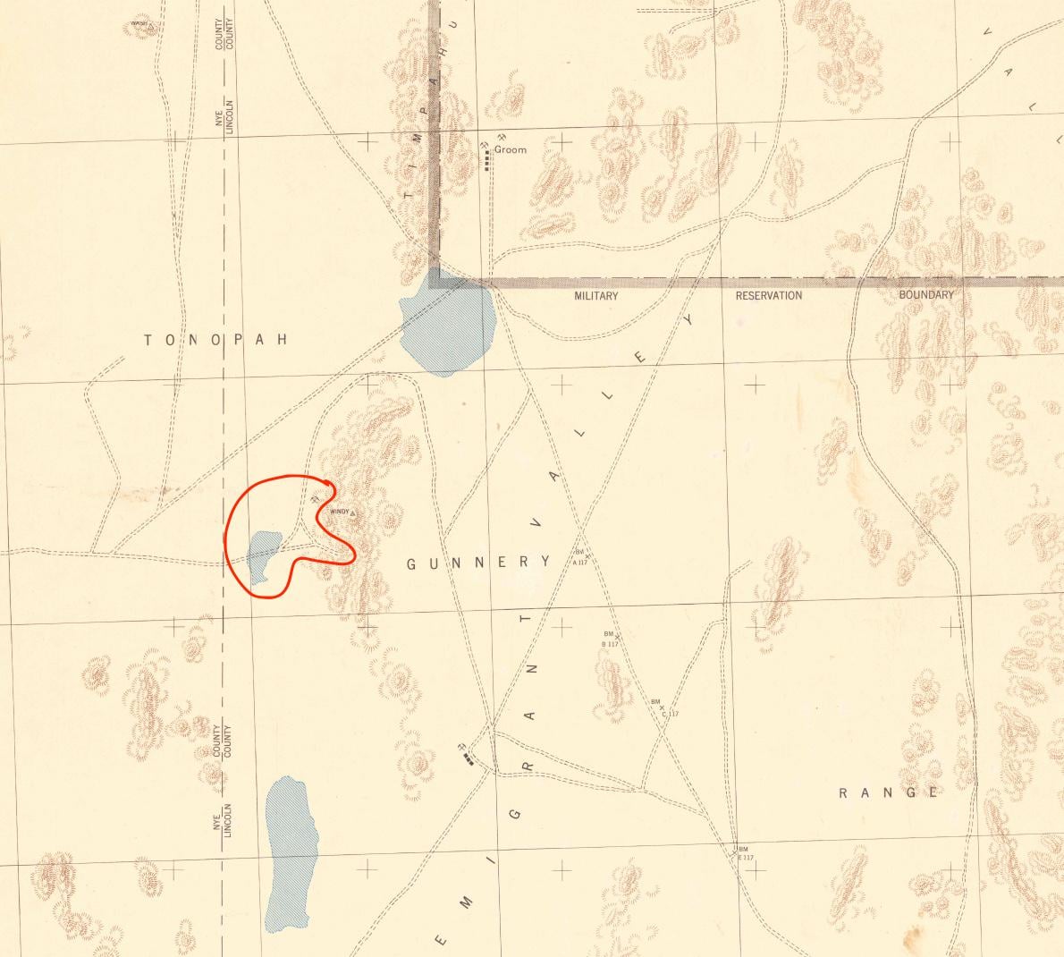
This is the 1942 Emigrant Valley quadrangle, compiled using 1941 aerial surveys. It appears to show Groom Lake (top), a smaller playa southwest (very likely Papoose Lake), multiple unimproved roads/tracks, several mining features
A couple things stood out to me:
- There’s a distinct unimproved road that branches off and runs INTO the mountain where S4 is reportedly located. This is just like Luigi described.
- There is also a mine there, which would explain both the access road and the possibility of existing underground excavation. Also, just as Luigi described.
- When comparing to later maps, that road and the mine label are gone.
I'm not 100% certain because the shape of the playa/Papoose Lake doesn’t match modern satellite imagery perfectly, but it’s pretty close when you consider its position relative to Groom Lake and the surrounding terrain.
by lionatthedoor
3 Comments
Submission Statement:
This is a 1942 USGS Emigrant Valley quadrangle compiled from 1941 surveys, which may align with the map Luigi Vendittelli referenced regarding Bob Lazar’s S4 location. It depicts Groom Lake, a smaller playa likely corresponding to Papoose Lake, and a spur road leading into the Papoose Range near a labeled mine. These features are absent on later maps. While not conclusive, it provides historical context showing prior access and mining activity in the area before the establishment of Area 51. Looking for input from others who have analyzed these maps in more detail.
Every mountain in Nevada (*the silver state*) has an old mine or two embedded in it along with old trails leading there.
I remember seeing the side of the mountain where it shows the large sidedoors and Google maps show the road leading up to the entrance. From what I remember this is the X Y. to S4 from a much earlier correspondence I read.
# 37°12’18.2″N 115°50’26.0″W