

A newly released image from NASA is offering a powerful new perspective on Mount Rainier, using advanced radar technology to reveal details invisible to the human eye. The image, tied to the agency’s NISAR mission, highlights how scientists are preparing to monitor Earth’s most dynamic landscapes with unprecedented precision. This breakthrough, documented by NASA, marks a major step forward in understanding volcanic structures and potential hazards.
A Radar Vision That Goes Beyond Traditional Imaging
Unlike conventional photography, this new view of Mount Rainier was created using synthetic aperture radar, a technology capable of penetrating clouds, darkness, and even surface vegetation. This allows scientists to observe subtle changes in terrain that would otherwise go unnoticed.
The image showcases the volcano’s structure in remarkable detail, revealing ridges, slopes, and geological formations shaped over thousands of years. These features are not just visually striking—they hold critical data about how the mountain is evolving.
What makes this approach so valuable is its consistency. Radar systems can capture reliable data regardless of weather conditions, a key advantage in regions like the Pacific Northwest, where cloud cover often limits visibility.
By analyzing these radar signals, researchers can detect ground deformation down to very small scales. These shifts may indicate volcanic activity, landslides, or other geological processes that could pose risks to nearby populations.
This capability transforms a single image into a dynamic scientific tool, enabling continuous monitoring rather than isolated observation.
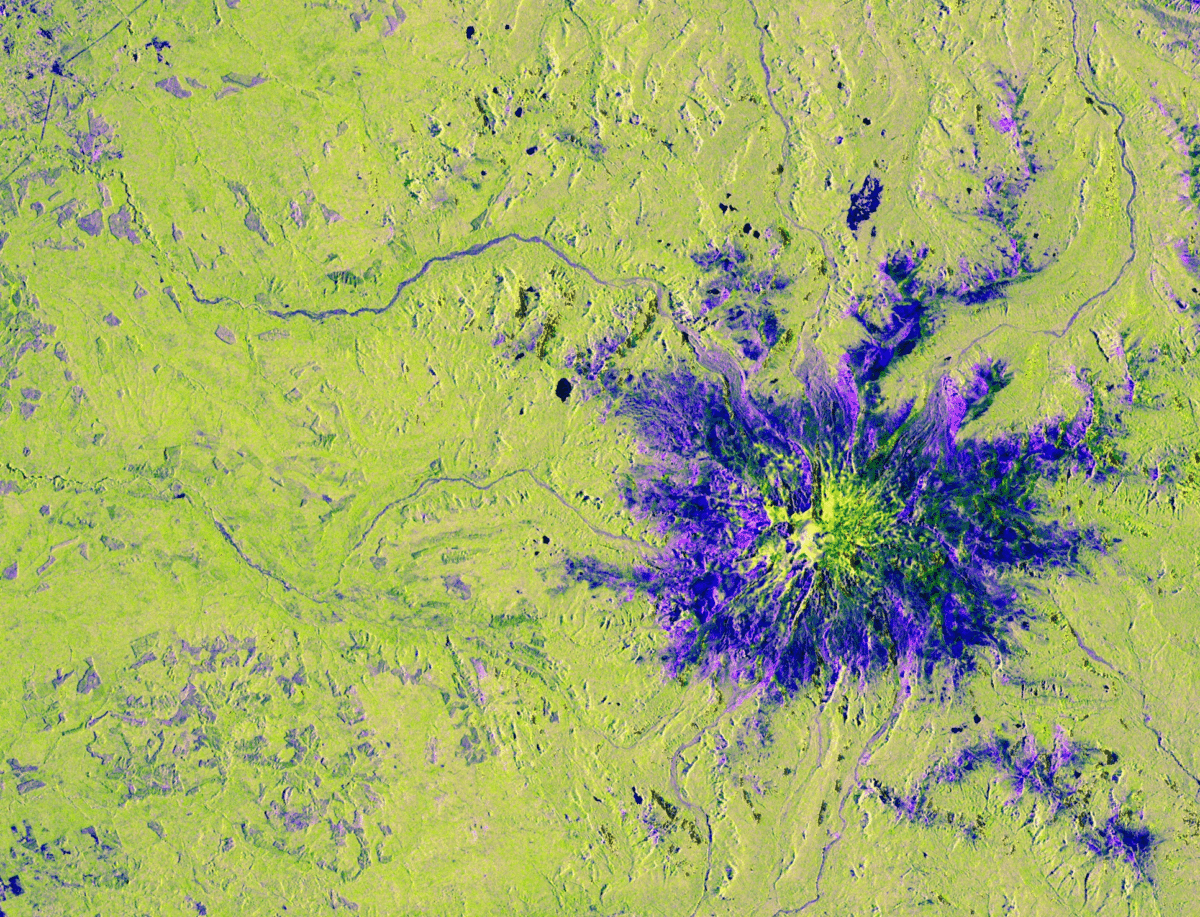 PIA26672-NISAR’s View of Mount Rainier
Credits: NASA/JPL-Caltech
The NISAR Mission And Its Scientific Ambitions
The image is part of preparations for the NASA-ISRO Synthetic Aperture Radar (NISAR) mission, a joint effort between NASA and the Indian Space Research Organisation. This mission is designed to track changes across Earth’s surface with extraordinary accuracy.
Mount Rainier serves as an ideal test subject due to its complex geology and status as one of the most potentially hazardous volcanoes in the United States. Its massive glaciers and steep slopes make it particularly prone to landslides and volcanic mudflows.
According to NASA, NISAR will orbit Earth and repeatedly scan the same locations, building a time-series dataset that reveals how landscapes shift over days, months, and years.
This long-term monitoring is expected to improve early warning systems for natural hazards, including earthquakes and volcanic eruptions. Scientists will be able to identify patterns that precede major events, offering valuable time for preparation and response.
The mission reflects a growing emphasis on combining space-based observation with Earth science to better understand planetary processes.
Why Mount Rainier Matters More Than Ever
Mount Rainier is not just a scenic landmark, it is an active stratovolcano located near densely populated areas in Washington State. Its history includes eruptions and large-scale mudflows that have reshaped the surrounding landscape.
Today, millions of people live within range of potential hazards associated with the volcano. This makes accurate monitoring a priority for both scientists and emergency planners.
The new radar image highlights areas where ice, rock, and volcanic material interact, offering clues about how the mountain might behave in the future. Even small shifts in these zones can signal larger changes underway.
Understanding these dynamics is critical for risk assessment. With tools like NISAR, scientists are moving closer to predicting not just if an event might occur, but when and how it could unfold.
This level of insight was not possible with earlier generations of observation technology.