

You may have seen my earlier posts on the Great Circle – that alignment of Giza, Nazca, Easter Island, Persepolis, Mohenjo-daro, all sitting on one great circle. It's been a staple of alternative history for years.
I'm the guy who actually tested it with data. Two papers, 7 databases, over 600,000 archaeological sites, every line of code open source.
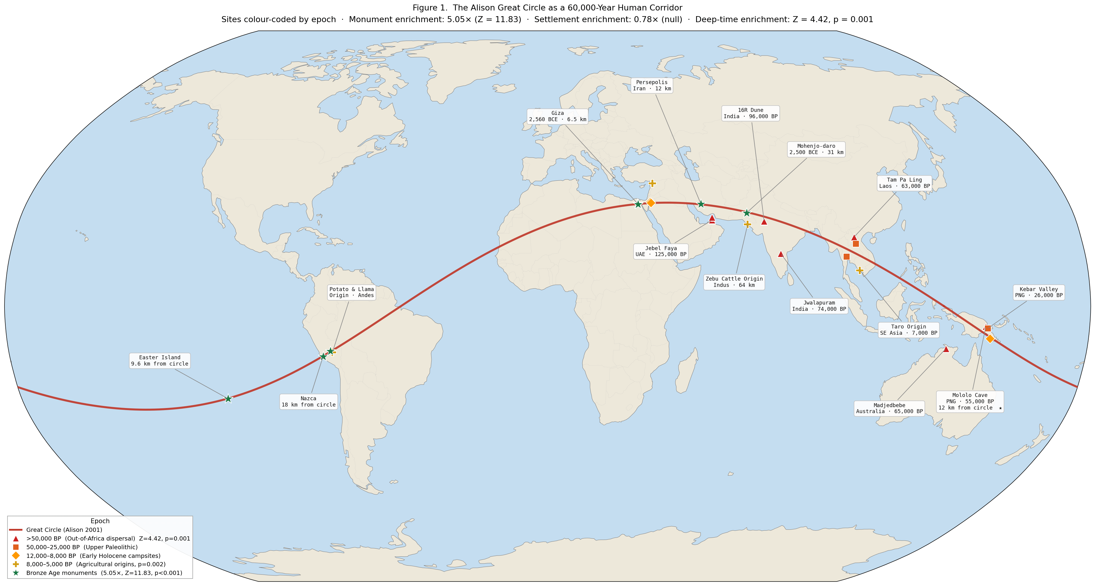
The alignment is real: Monuments cluster along this circle at 5x the expected rate. 10,000 random circles tested. Zero matched.
What blew my mind: settlements DON'T cluster on it. The villages and farms built by the same civilizations, in the same regions, ignore the circle completely. This rules out "it just passes through populated areas."
And it goes back WAY further than the pyramids.
40% of Out-of-Africa dispersal sites — the literal first humans to leave Africa 60,000 years ago — fall on this line. The corridor shows up in every epoch of human history except the Ice Age, when Arabia was impassable desert.
9 of 24 places where agriculture was independently invented sit within 500 km. Three continents. Cultures that never met.
Bronze Age monuments sit directly on top of spots where people were making campfires 10,000 years earlier.
What it ISN'T:
- Not astronomical (4 tests, all null)
- Not a lost civilization (LESS activity before the Younger Dryas, not more)
- Not aliens (obviously)
- Not magnetic, geological, or navigational
What it IS:
A natural walking corridor. Good water, passable terrain, manageable climate. The first humans followed it out of Africa. They stopped at natural gathering points. Those spots accumulated cultural significance for 60,000 years. And when civilizations arose, they built their most important structures at those ancient places.
The monuments remember what we forgot.
Latest Substack article breaking it down: https://open.substack.com/pub/thegreatcircle/p/the-great-circle-is-60000-years-old
Paper: https://doi.org/10.5281/zenodo.19209978
Interactive globe: https://thegreatcircle.earth
All code: https://github.com/thegreatcircledata/great-circle-analysis
by tractorboynyc
5 Comments
There’s a Third Rock From the Sun episode that explains this phenomenon pretty well it escapes me which one it is but internet let’s find it
A natural walking corridor to South America?
Hominid species left Africa more than 1.8 million years ago and modern humans left Africa staring 200,000 years ago.
I also point this out every time because you keep using the same shortlist as examples. Easter Island and Persepolis were settlements. Polis means city and Persepolis was the capital of the Achaemenid Empire. Easter island has a total land area of ~163 square kilometers and the people who built the megaliths lived on it. “Settlements don’t cluster on the line” isn’t a valid statement when 4 of your primary examples are settlements themselves.
Don’t even get me started on Giza. The pyramids are well within 50 km of the two primary settlements in Egypt. Mohenjo-daro is a settlement too.
People lived in all these places before, during, and after they were built.
It’s not a walking or travel corridor, it’s a coincidence. They happen all the time.
You can pick any number of fixed points around the world and draw a wiggly line joining them together.
I’ve been researching metallic libraries in South America for a while now. The most compelling evidence IMO is the radiation readings. What do you all think?