

The apparent disappearance of the mysterious disc has prompted online discussion about whether government entities are purposefully obscuring genuine alien-related imagery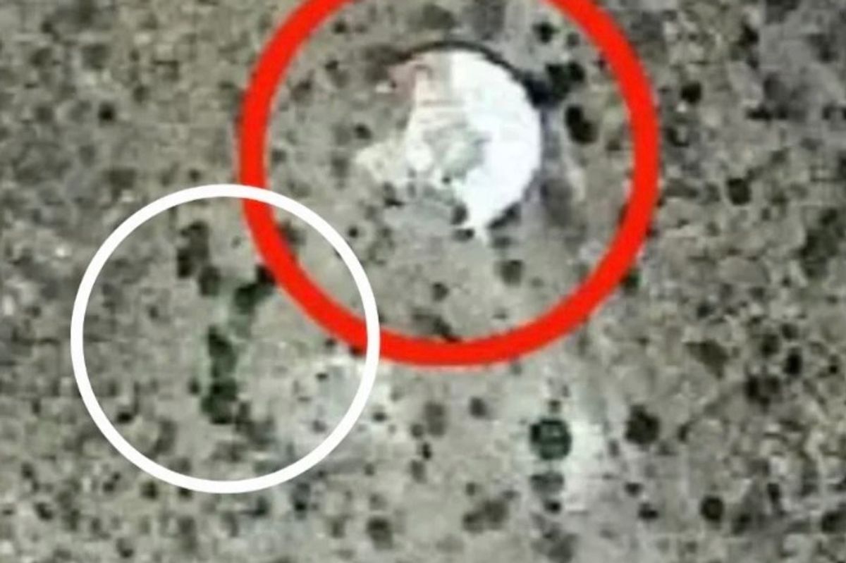
Images originating in the state’s high desert appeared to show a luminous white or silver object(Image: Reddit)
Images of a mysterious disc found on Google Earth have sparked new theories related to alien activity in New Mexico.
Images originating in the state’s high desert appeared to show a luminous white or silver object, which some observers believe is a UFO, wedged in a hillside. Newer pictures suggest the mysterious object is no longer visible, instead showing buildings or blurred areas, according to comparative studies of older and more recent imagery.
The apparent disappearance of the mysterious disc has prompted online discussion about whether government entities are purposefully obscuring genuine alien-related imagery. One point of contention is the pattern of vegetation surrounding the object, which reportedly remains consistent across the earlier images. Users have used this as a pillar in their argument that the location has been altered.
READ MORE: US congressman claims he’s received death threats after demanding UFO secrets made publicREAD MORE: Terrifying Baba Vanga UFO prophecy about to come true as Donald Trump makes alien disclosure
Reports of altered images have spread far beyond New Mexico as satellite hawks on Reddit have reportedly identified similar instances involving pictures taken in California and Baja Norte.
The seafloor near Point Mugu in California and the region southeast of Isla Guadalupe off Baja Norte, UFO enthusiasts assert, were once available in high resolution but have since been replaced with blurred imagery featuring a 2026 watermark in Google Earth.

Analysts assert that historical imagery is not tangible evidence of crashed UFOs(Image: Reddit)
Moreover, these locations align with regions of strategic or military interest, and Google has largely kept silent on the reasoning behind its decision to obscure certain imagery.
This has led to speculation of intentional cover-ups, especially in areas containing sensitive infrastructure.
Experts have undercut those claims, noting that changes in Google Earth are typical and can stem from several factors, from newer satellite data to image resolution adjustments to security-related redactions.

Reports of altered images have spread far beyond New Mexico(Image: Reddit)
However, newly blurred images can be applied to shield military or critical infrastructure sites from exposure, according to analysts. This does not suggest the government conducts these updates to hide evidence of extraterrestrial activity.
The frenzy among alien believers has not subsided. In one forum reviewed by the International Business Times, one commenter said that “there was a guy that hiked out there” and “it was like an antenna base.”

The frenzy among alien believers has not subside despite opposing claims from experts(Image: Reddit)
Another one wrote those photos were of a “round concrete base with a collapsed satellite dish.”
Other opponents of the speculation noted that discrepancies in the visual appearance can stem from the timing of the photo, current weather conditions and seasonal changes altering the vegetation.
Therefore, analysts assert that historical imagery is not tangible evidence of crashed UFOs. Reddit users have posted side-by-side comparisons of older and newer images in alien-related forums. These continue to fuel suspicion of a potential government cover-up.
For the latest local news and features on Irish America, visit our homepage here.