

 An artist’s impression of two Celeste satellites in orbit. Credit: ESA
The European Space Agency’s Celeste LEO PNT mission, carrying two satellites, is due for lift-off next month.
The Celeste mission is intended to test the provision of GNSS-like timing signals, but from low-Earth orbit (LEO), for positioning, navigation and timing (PNT) applications on Earth.
Celeste will trial what are being described as next-generation technologies and new frequency bands for satellite navigation.
The idea is to see how a satellite constellation flying in lower orbits can complement and enhance the service provided by Europe’s Galileo system, which circles the planet at medium-Earth orbit altitudes.
LEO orbits bring the potential for greater signal strength to reduce the effectiveness of jamming and spoofing, and for better penetration in current signal-poor areas such as cities with lots of high-rise buildings.
The first launch, due on 24 March, will see twin satellites propelled into orbit aboard a Rocket Lab Electron launch vehicle from the company’s Māhia Launch Complex in New Zealand.
On-orbit testbeds
The two demonstrator CubeSats will be followed by eight more, larger, satellites under development by two teams, one led by GMV and the other by Thales Alenia Space. Each consortium will build four of the satellites.
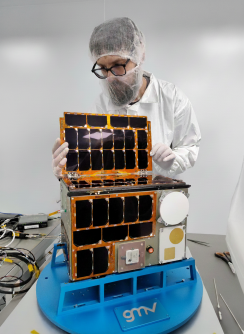 One of the Celeste CubeSats. Credit: Galaxia European Space Applications Park
Those eight satellites will feature:
S-band two-way navigation signals, for advanced positioning capabilities using 5G satellite waveforms.
C-band signals, for additional resilience against jamming and interference.
UHF-band signals, for enhanced penetration and in-door positioning.
“On top of the eight satellites, an additional one will include a payload to test miniaturised atomic clocks on board, along with other technologies,” says Roberto Prieto-Cerdeira, ESA’s Celeste project manager.
All of the satellites will orbit at altitudes of around 500 to 560 kilometres.
They will serve as on-orbit testbeds for a variety of applications and sectors, such as autonomous vehicles, maritime navigation, critical infrastructure, polar and arctic operations, wireless networks, emergency services, asset tracking and IoT.
“By carrying out these experimentation and demonstration activities in orbit, we are opening a platform where ESA can work hand-in-hand with end-user communities and stakeholders to demonstrate innovative technologies in satellite navigation, push boundaries and demonstrate services in conditions that mirror the real world,” adds Roberto.