

Through its advanced satellite technologies and space-based systems, the EU Space Programme is transforming how aircraft navigate, communicate, and operate across European airspace and beyond. Innovations from EGNOS, Galileo, Copernicus, and soon IRIS², are changing the way we fly. Precision landing and navigation systems developed under the EU Space Programme are improving the safety of passengers globally, demonstrating Europe’s commitment to technological leadership in the aerospace sector. In this Observer, we explore how the EU Space Programme is driving the evolution of aviation and what this reveals about Europe’s strategic autonomy in the digital aerospace age.
The aviation industry stands at a critical juncture. With air traffic projected to continue growing and environmental pressures mounting, traditional aviation systems face complex challenges. The EU Space Programme is contributing to this transformation through sophisticated satellite systems and data services, which are supporting the industry’s transition towards more sustainable operations while improving passenger safety and efficiency in the air.
EGNOS: Pioneering precision in European aviation
Designed and developed by the European Space Agency (ESA), and European Organisation for the Safety of Air Navigation (Eurocontrol), under the authority of the European Commission, the European Geostationary Navigation Overlay Service (EGNOS) is Europe’s regional Satellite-based Augmentation System (SBAS) and serves as one of Europe’s most important space applications for aviation. SBASs are used to augment the signals of Global Navigation Satellite Systems (GNSS) so that they can be used for Safety-of-Life applications such as precision approaches in aviation.
Managed by the European Union Agency for the Space Programme (EUSPA) and operated by the European Satellite Services Provider (ESSP), the system provides significant precision improvements over standard GPS. EGNOS builds upon GPS performance, using payloads hosted on three geostationary (GEO) satellites together with a network of ground stations, providing positioning accuracy of better than two metres, while GPS alone is only capable of 15 to 20 metres. This accuracy enables critical Safety-of-Life applications, providing a valuable integrity message warning users of any malfunction of the GPS signal within six seconds, helping to ensure the safety of air operations.
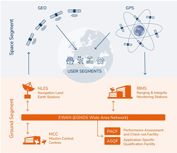
The EGNOS system architecture combines space and ground segments, including geostationary satellites, GPS signals, and ground monitoring stations to serve multiple user segments including aviation. Credit: European Union, EUSPA.
Currently, more than 500 airports across Europe use EGNOS, enabling planes to land safely under difficult or even zero visibility conditions. This delivers substantial improvements to operational efficiency across Europe, it is estimated that more than 80,000 flight delays and 20,000 diversions have already been avoided across Europe at EGNOS-equipped airports. EGNOS-enabled precision approaches reduce fuel consumption through more direct flight paths and optimised landing procedures, resulting in lower fuel consumption and emissions, reducing the aviation industry’s environmental impact.
EGNOS also supports enhanced safety levels through LPV-200 procedures which serve as backup to Instrument Landing Systems (ILS), first implemented in 2016 at Charles de Gaulle Airport in Paris, France. These capabilities have particularly supported smaller and regional airports and airfields across Europe and some neighbourhood countries, providing a cheaper alternative to traditional ILS.
EGNOS V3, currently in development, will improve navigation performance and support aviation stakeholders with essential integrated safety features through Galileo support, as well as provide improved cybersecurity capabilities, ensuring the protection and confidence of its users.
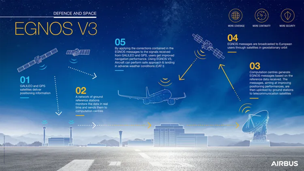
EGNOS V3 system overview showing enhanced capabilities including improved coverage, continuity, and security through integrated satellite and ground infrastructure operations. Credit: Airbus.
Aviation’s secure future
As a flagship component of the EU Space Programme, Galileo, the European Global Navigation Satellite System, provides critical capabilities for modern aviation which extend far beyond basic positioning.
The world is going through turbulent times, with malicious actors increasingly targeting civil aviation through GNSS spoofing and jamming. In September 2025, the European Parliament held a debate on the growing threat of satellite navigation interference following reports that the GPS of a plane carrying European Commission President Ursula von der Leyen was disrupted when flying back from a tour of Eastern European countries.
Built from the outset with robustness and reliability in mind, Galileo’s architecture has several features which help preserve the integrity, authenticity, and continuity of its signals. It uses multi-frequency signals (E1/E5/E6), redundancy in constellation and control segments, and continuous integrity monitoring to strengthen resistance to interference and anomalies. Now fully operational, Open Service Navigation Message Authentication (OSNMA) adds a cryptographic authentication layer, embedding a signature in the navigation message so that receivers can verify the origin of the signal and reject spoofed transmissions.
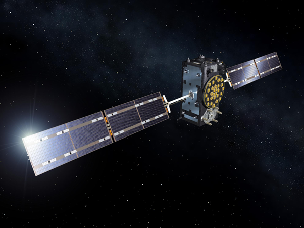
A Galileo navigation satellite in orbit, part of Europe’s Global Navigation Satellite System which provides OSNMA authentication services to protect aviation from signal spoofing. Credit: ESA.
OSNMA became operational in July 2025, resulting from over a decade of collaboration between the European Commission, EUSPA, ESA, and key European industrial partners. With OSNMA, Galileo became the first GNSS to provide free, open, and globally available signal authentication, strengthening Europe’s position as an international leader in secure satellite navigation. You can read more about OSNMA in this Observer article.
Precision ground data for safer skies
Modern aviation is facing increasing complexity in flight procedure design, with traditional terrain data sources often lacking the precision and global coverage required for next-generation Performance-Based Navigation (PBN) procedures which aircraft must follow without pilot modification.
EUSPA, in collaboration with European Satellite Services Provider (ESSP), responded to this challenge by integrating Copernicus Digital Elevation Model (DEM) GLO-30 data into flight procedure design workflows. The Copernicus Global DEM provides 30-metre-resolution terrain information, representing a new standard in accuracy for Flight Procedure Design (FPD) providers who previously relied on fragmented global and local sources.
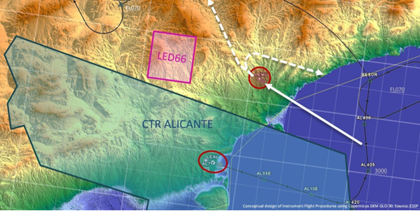
Copernicus DEM GLO-30 provides high-resolution terrain information supporting safer flight procedure design, as demonstrated in this conceptual approach to Alicante Airport in Spain. Credit: European Union, EUSPA / ESSP.
Following successful validation with three FPD organisations and the release of comprehensive user guidelines, this capability now enables more precise obstacle assessment and safer approach procedures. Complementary Copernicus datasets, such as the Global Human Settlement Layer – Population Grid (GHS-POP), also support noise impact assessments for sustainable aviation operations.
This integration demonstrates Europe’s commitment to leveraging its space assets holistically, transforming how aviation professionals design the critical procedures which ensure millions of passengers reach their destinations safely every day.
Future developments and emerging technologies
The upcoming Infrastructure for Resilience, Interconnectivity and Security by Satellite (IRIS²) satellite communications constellation will further amplify the EU’s space capabilities. As the EU Space Programme’s third flagship component, IRIS² will complement the services provided by Copernicus and Galileo, supporting a large number of potential commercial applications, including aviation.
Together, IRIS², Copernicus, and Galileo illustrate how Europe is shaping the future of space-enabled systems, enabling a more competitive, connected, and sustainable European aviation sector which benefits citizens, businesses, and the planet.
EU Space technologies deliver tangible benefits for aviation: improved safety and faster flights for millions of passengers, and economically and environmentally sustainable business operations for airlines and airports across Europe. More importantly, they demonstrate Europe’s capability to design, deploy, and operate complex space systems which serve aviation needs.
By combining data, connectivity, and navigation across Copernicus, Galileo, and IRIS², the EU Space Programme provides the foundation necessary for the aviation industry’s continued evolution. The continued and further integration of space technologies will further strengthen Europe’s position in the global aerospace market, delivering secure, sustainable, and efficient aviation solutions for Europeans and its international partners.