
TAIWAN PROWESS:
FS-8A’s highest-resolution images could be useful in disaster prevention, national security, mapping and precision agriculture, the agency said
By Sam Garcia /
Staff writer, with CNA
The Formosat-8 Chi Po-lin Satellite (FS-8A), the first satellite in Taiwan’s first domestically produced optical remote sensing satellite constellation, has delivered results beyond expectations, the Taiwan Space Agency (TASA) said yesterday after the satellite released its first images on Wednesday last week.
FS-8A was launched on Nov. 29 last year.
It began official imaging missions last month after undergoing rigorous functionality verifications, orbital maneuvers and more than 100 imaging tests.

Photo courtesy of the Taiwan Space Agency
The first batch of images included Hsinchu Science Park (新竹科學園區), Tainan’s Anping District (安平), Kaohsiung’s Singda Harbor (興達港), Japan’s National Stadium in Tokyo and Barcelona Airport.
The image clarity and signal-to-noise ratio exceeded the original design specifications, TASA said.
The satellite also supports scientific missions, the agency said, adding that FS-8A has a dual-band imager of atmospheric transient (DIAT) events, and an electron temperature and density probe (TeNeP), which were developed by National Cheng Kung University (NCKU), it said.
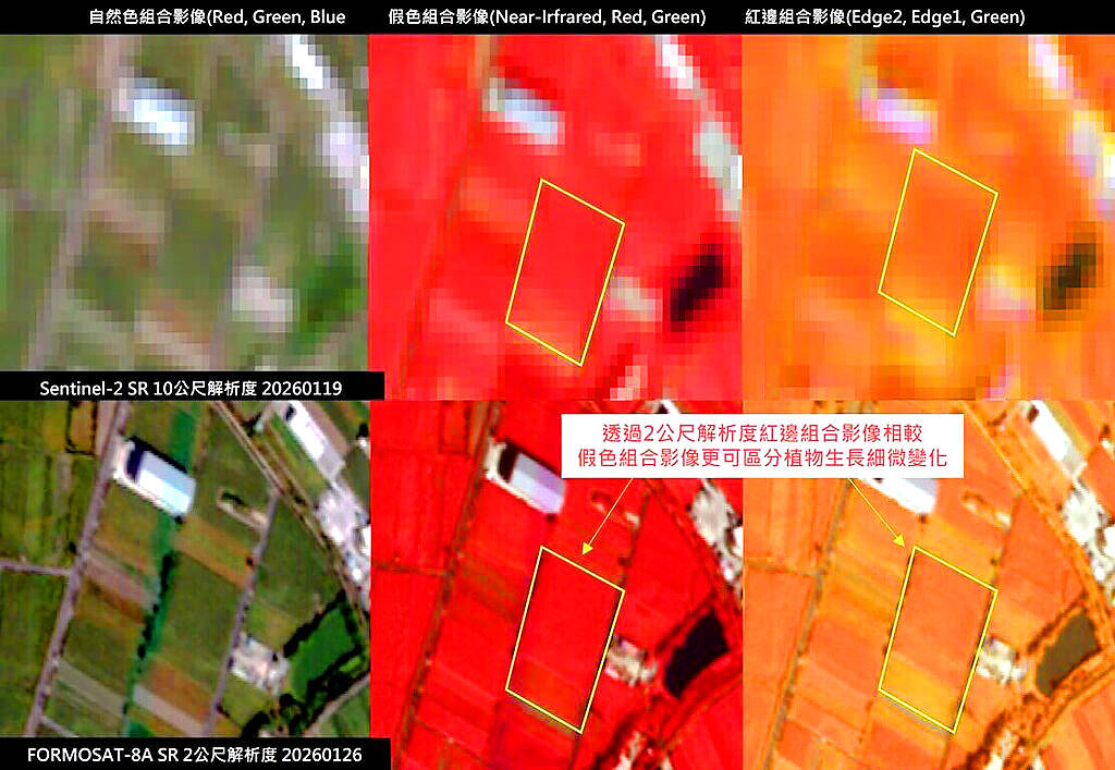
Photo courtesy of the Taiwan Space Agency via CNA
The instruments completed testing and their first scientific measurements during the satellite’s early orbital operations, TASA said.
All systems are working normally, and the satellite could begin science missions, it said.
They would be primarily used to study atmospheric electricity, ionospheric physics and high-energy physics, it added.
The TeNeP tracks electron conditions in Earth’s upper atmosphere and can spot key space weather events such as equatorial anomalies and plasma bubbles, acting like a “thermometer and blood pressure monitor” for space, the NCKU team said.
These data are crucial for keeping satellites, communications and navigation systems safe, it said.
The DIAT uses high-sensitivity imaging to capture the Earth’s city lights, clearly identifying urban areas, the team said, adding that it was the first time a domestically produced satellite has fully recorded the Earth’s nighttime light patterns.
These achievements demonstrate Taiwan’s exceptional space technology, NCKU physics professor Chen Bing-chih (陳炳志) said, adding that they marked a milestone for ionospheric research, space weather forecasting and global communications.
FS-8A’s main mission is optical remote imaging, and it can capture the world’s highest-resolution images in the red-edge bands, TASA said.
These bands are highly sensitive to chlorophyll content and plant conditions, making them useful for disaster prevention, national security, land monitoring, mapping and precision agriculture, the agency said.
The Formosat-8 project is to encompass eight optical remote-sensing satellites, six of which have native resolutions of 1m, while the other two have resolutions of less than 1m.
The second Formast-8 satellite, FS-8B, is nearly complete and would soon begin tests, with launch expected via a SpaceX rocket at the end of this year.