

While a part of the United States braved extreme winter cold, January 2026 brought sweltering summer conditions to many parts of Australia.
Australia’s area-averaged mean temperature was 1.90 degrees Celsius (3.42 degrees Fahrenheit) above the 1961–1990 average, making it the fourth-warmest January since the start of observations in 1910, according to the Bureau of Meteorology (BoM). Contributing to this was a late-month heatwave in the country’s southeast that was especially intense between January 26 and January 30. During that period, numerous weather stations in South Australia, New South Wales, and Victoria recorded record-high daily temperatures.
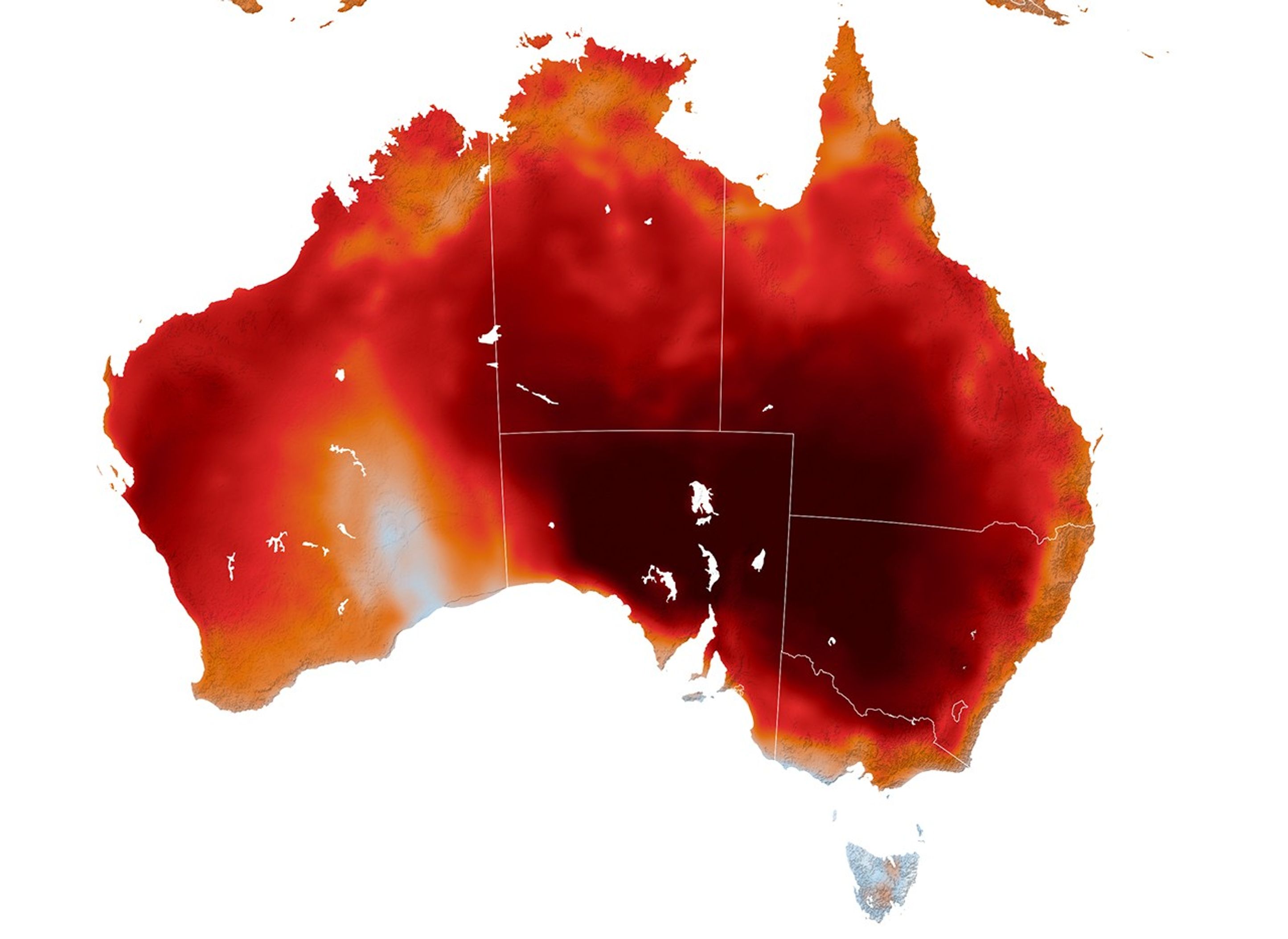
The heatwave’s intensity and extent are evident in this map, which shows air temperatures at 03:00 Universal Time (2 p.m. local time in Victoria) on January 29, modeled at 2 meters (6.5 feet) above the ground. It was produced with a version of the GEOS (Goddard Earth Observing System) model, which integrates meteorological observations with mathematical equations that represent physical processes in the atmosphere. The darkest reds are where the model indicates temperatures reaching or exceeding 45°C (113°F).
According to BoM, the hottest temperatures of January 2026 were measured in two places in South Australia: in the town of Andamooka on the 29th and at the Port Augusta airport on the 30th, where temperatures reached 50.0°C (122.0°F). In both New South Wales and Victoria, the month’s hottest day was on the 27th, when temperatures reached 49.7°C (121.5°F) at a station in Pooncarie and 48.9°C (120.0°F) at stations in Walpeup and Hopetoun.
The heatwave brought significant human and public-health effects, including the increased risk of heat-related illness. Organizers of the Australian Open tennis tournament in Melbourne, Victoria, suspended play on some courts and closed roofs to provide shade as part of an “extreme heat policy” to protect players and spectators, according to news reports.
The recent warmth followed another bout of heat earlier in the month that, combined with strong winds and dry conditions, created dangerous fire conditions. Numerous bushfires were burning across Victoria on January 9 as officials urged people to evacuate. By mid-month, news reports indicated that the fires had destroyed hundreds of structures and killed tens of thousands of livestock.
NASA Earth Observatory image by Lauren Dauphin, using GEOS data from the Global Modeling and Assimilation Office at NASA GSFC. Story by Kathryn Hansen.
Australian Broadcasting Corporation (2026, January 15) Hundreds of satellite images capture Victoria’s destructive bushfires erupting. Accessed February 10, 2026.
Australian Broadcasting Corporation (2026, January 14) Tens of thousands of livestock confirmed dead as Victorians return to bushfire-ravaged communities. Accessed February 10, 2026.
Bureau of Meteorology (2026, February 2) Australia in January 2026. Accessed February 10, 2026.
Bureau of Meteorology (2026, February 2) New South Wales in January 2026. Accessed February 10, 2026.
Bureau of Meteorology (2026, February 2) Victoria in January 2026. Accessed February 10, 2026.
Bureau of Meteorology (2026, February 1) South Australia in January 2026. Accessed February 10, 2026.
The New York Times (2026, January 8) Three Reported Missing in Australia as Fires Rage in ‘Catastrophic’ Conditions. Accessed February 10, 2026.
VIC Emergency (2026, January 9) Bushfires could spread in catastrophic conditions update 9 January 2026. Accessed February 10, 2026.