

An ESA backed project brings a new standard for monitoring urban greenery across European cities
The Czech company ASITIS has successfully completed the European Space Agency (ESA) project UpGreen, which provides cities with a new level of insight into the condition and distribution of urban greenery. In pilot studies in Copenhagen (Denmark) and Lisbon (Portugal), the team analysed 587,026 trees and demonstrated that combining satellite imagery, municipal data, and AI can assess each individual tree, including its stress level, productivity, long term
survival capacity, carbon sequestration, and cooling effect.
Cities received clear map layers, reports, and visual outputs that support targeted maintenance, smarter planting, and better investment decisions.
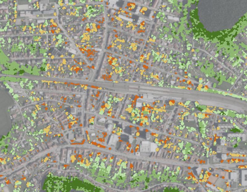
The methodology has already been tested in the Czech Republic,
in the town of Kurim.
Martin Vokral, CEO of ASITIS, explains: “Cities need to manage greenery as strategically as transport or
energy. UpGreen delivers detailed data at a fraction of the cost of traditional tree inventories.”
To explore project results, case studies, and practical applications for cities go to: https://asitisready.com
ASITIS s.r.o
Address: Vazneho 10, 621 00, Brno
email: kancelar@asitis.cz
website: https://asitisready.com
+420777963851
ASITIS is a European consultancy focused on climate adaptation and mitigation for cities, regions and investors. We combine science, satellite data and practical planning tools to help our clients make informed, defensible decisions in a changing climate.
A key part of our work is urban greenery analysis. Through our UpGreen platform we assess the real condition and climate benefits of trees and green infrastructure, including carbon sequestration, cooling effect, tree stress, productivity and survival capacity. These analyses help cities protect existing greenery, target investments and avoid costly losses.
We also implement the internationally recognised 3+30+300 rule as a practical standard for healthy urban environments. We analyse whether residents can see at least three trees, whether neighbourhoods reach thirty percent tree canopy cover and whether people live within three hundred metres of accessible green space. The outputs are clear maps, indicators and recommendations that directly support planning, adaptation strategies and funding applications.
ASITIS works across the public and private sector, from small municipalities to large cities and strategic investors. Our outputs are based on verified data, transparent methods and long term perspectives, ensuring that adaptation measures deliver real environmental and social benefits.
If you are planning greener cities, climate resilient projects or ESG aligned investments, ASITIS is ready to help you turn data into action.
This release was published on openPR.