

The world’s premier catalyst for understanding Earth as a unified and dynamic system, empowering humanity through transformative insights into Earth system science.
Mission
To advance scientific understanding of Earth’s interconnected systems by integrating NASA’s satellite, airborne, surface, and partner datasets; developing predictive models and data analysis tools; and disseminating peer-reviewed discoveries, tools, and insights to improve societal outcomes.
Overview
NASA’s Earth System Science Research Program (ESSRP), formerly known as the Research & Analysis (R&A) Program, advances Earth system science by enabling the use of satellite, airborne, and ground-based observations, along with modeling approaches, to improve understanding of Earth processes. In collaboration with domestic and international partners, ESSRP ensures that findings inform NASA missions, are published in peer-reviewed literature, and are shared with the broader scientific community and public.
ESSRP supports research pertaining to five Earth science spheres: Atmosphere, Biosphere, Cryosphere, Geosphere, and Hydrosphere. Details on the key research questions, relevant satellite and airborne missions, satellite calibration and validation efforts, research opportunities, research programs, and upcoming meetings and events corresponding to each science sphere can be found below.
Science Spheres

Atmosphere
Atmosphere fosters research and innovation targeting the dynamics and thermodynamics of the atmosphere, its physical and chemical composition, and the interdependent impacts that these have on the Earth’s radiative balance, air quality, and weather.

Biosphere
Biosphere provides foundational knowledge on interactions between and within terrestrial and aquatic ecosystems, along with changes in their biogeochemistry and biodiversity. The goal is to further understand the Earth system in which both human-induced and natural changes influence productivity and the availability of natural resources.

Cryosphere
Cryosphere investigates polar ice, including the Antarctic and Greenland ice sheets, polar glaciers, and sea ice in the Arctic and Southern Oceans, with a focus on satellite and airborne observations. Cryosphere also seeks to improve our understanding of processes, advance prediction, and link the cryosphere to the Earth system.

Geosphere
Geosphere studies processes and changes in the Earth’s core, mantle, and crust along with surface topography and geology, and the hazards they generate. Geosphere relies on essential measurements including gravity, GNSS, InSAR, lidar, stereo optical, and hyperspectral observations. Geosphere also contributes to geodesy and geodynamics research along with cross-Sphere research.

Hydrosphere
Hydrosphere improves the observation, understanding, and prediction of water and energy in the Earth System across land, ocean, and the atmosphere through the integration of measurements from satellites, surface networks, and airborne campaigns.
The table below shows which Sphere each previous science program now resides. This list is non-exhaustive of all current research areas. Please refer to the Sphere pages for more information.
Previous Research ProgramCurrent Sphere or Enabling CapabilitiesAtmospheric Composition Modeling and Analysis ProgramAtmosphereAtmospheric DynamicsAtmosphereRadiation SciencesAtmosphereTropospheric CompositionAtmosphereUpper Atmosphere ResearchAtmosphereBiological Diversity ResearchBiosphereLand-Cover and Land-Use ChangeBiosphereOcean Biology and BiogeochemistryBiosphereTerrestrial EcologyBiosphereCryospheric SciencesCryosphereEarth Surface and InteriorGeospherePhysical OceanographyHydrospherePrecipitation ScienceHydrosphereTerrestrial HydrologyHydrosphereWater and Energy CycleHydrosphereInterdisciplinary ScienceEmbedded in all SpheresAirborne Science ProgramEnabling Capabilities: Airborne Science ProgramEarly Career ResearchEnabling Capabilities: Early Career ResearchGLOBEEnabling Capabilities: Ground Networks, Calibration Labs, and CrowdsourcingModeling, Analysis, and PredictionEnabling Capabilities: Integrated Earth System ModelingScientific ComputingEnabling Capabilities: Integrated Earth System Modeling
Research Leadership
Earth Observatory Image of the Day
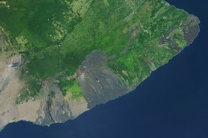
A Hot and Fiery Decade for Kīlauea
6 min read
The volcano in Hawaii is one of the most active in the world, and NASA tech makes it easier for…
Dec 9, 2025
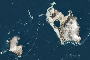
Islands of Fire and Ice Veiled in Cloud
3 min read
Puffs of low-level clouds mingle with the volcanic terrain of Candlemas and Vindication islands in the remote South Atlantic.
Dec 8, 2025
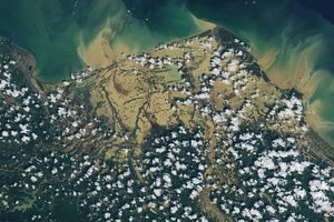
Senyar Swamps Sumatra
3 min read
A rare tropical cyclone dropped torrential rains on the Indonesian island, fueling extensive and destructive floods.
Dec 5, 2025