

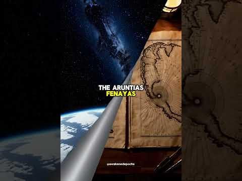
The Piri Reis Map was drawn in 1513. What makes it fascinating is that it seems to depict the coastline of Antarctica, without ice.
Modern radar only confirmed this subglacial shape in the 20th century, and yet this 500-year-old map hints at geographic details supposedly unknown until recent times.
Some argue it’s coincidence or cartographic misinterpretation. Others wonder if it's surviving knowledge from a lost seafaring civilization.
I put together a short 50-second visual summary for those curious:
📽️ https://www.youtube.com/shorts/ojHHQcW3KZ8
Is this just misunderstood cartography, or could ancient explorers have known more than we give them credit for?
by AwakenedEpochs